


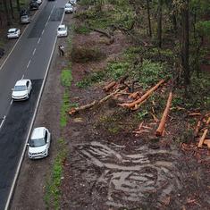


Parts of Assam and Meghalaya are among zones in India that are prone to the greatest rainfall-driven soil erosion, said a study that provides a national-scale assessment of rainfall erosivity over India.
Rainfall erosivity or R-factor is the erosive force of rainfall and reflects the potential of rain to cause soil degradation. About 68.4% of total eroded soil in India is affected by water-driven erosion, and rainfall erosivity is a major contributor to that erosion and land degradation.
The study by the Indian Institute of Technology, Delhi has developed the Indian Rainfall Erosivity Dataset, a pan-India assessment of rainfall erosivity over India, using gridded precipitation datasets. The Indian Rainfall Erosivity Dataset map is available freely for public use and expands the scope of understanding of rainfall-induced erosion over India.
“The current assessments of rainfall erosivity in India are limited to catchment or regions specific. R-factor was estimated by Tiwari et al, (2016) for India, but only 52 rain-gauge stations had been considered in this study, which is very less to assess rainfall erosivity for a nation like India which has diverse climate properties,” Manabendra Saharia at IIT Delhi told Mongabay-India.
“There is a good agreement between locations that we know experience erosion and those that have high rainfall erosivity,” added Saharia. “But this is the first step in a full-scale erosion study. We will be able to determine the extent of contribution of rain to erosion after these series of papers are complete this year.”
Rainfall-induced erosion
The study tapped into multiple national and global gridded precipitation datasets covering 40 years of data to develop a high-resolution map highlighting areas prone to rainfall-induced erosion. The datasets used are Indian Monsoon Data Assimilation and Analysis, India Meteorological Department and the global Climate Hazards Group InfraRed Precipitation with Station data database.
It is a step towards building a national soil erosion model for India, they said, adding that the map will help expand soil conservation measures to vulnerable areas.

In a second study by IIT Roorkee, also published this year, researchers have developed a risk map of rainfall erosivity using a high-resolution satellite rainfall dataset of 18 years. The study notes that the summer monsoon is the most erosive season, accounting for about 85% of the annual rainfall erosivity in India. It found that northeast India and the Western Ghats receive “high-intensity rainfall in the summer monsoon and have significantly high erosivity density”.
According to the IIT Delhi study, the average R-factor value estimated for India is 1,200 MJ-mm/ha/h/yr, while the maximum value (most vulnerable to rainfall erosivity) was 23,909.21 MJ-mm/ha/h/yr in the Laitknsew and Cherrapunji region of East Khasi Hills in Meghalaya state, one of the wettest regions in the world. The minimum R-factor value (least vulnerable to rainfall erosivity) in the cold and dry Shahi Kangri mountain region of Ladakh is 8.10 MJ-mm/ha/h/yr.
Other affected areas
Other states affected significantly by rainfall-induced soil erosion are Arunachal Pradesh, Bihar, eastern Uttar Pradesh and Chhattisgarh. At the district level, districts in Assam and Meghalaya are heavily affected by rainfall erosivity while cold and dry Leh district is the least vulnerable with the lowest rainfall erosivity factor.
“Soil of mostly loamy, silt loamy, sand clay loamy, and clay loamy texture classes are present in Assam and Meghalaya regions which do not show ample resistance to soil erosion due to water,” explained Manabendra Saharia about the reasons that make Assam and Meghalaya more prone to soil erosion. “Most of these regions are also along slopes and do not adhere to adequate soil conservation practices.”
Raindrops that pound down on Assam and Meghalaya and in other northeastern states are also bigger and carry more energy as they hit the soil, explained Nabansu Chattopadhyay, a former scientist with the agricultural meteorological division at India Meteorological Department, Pune, India. “With soil erosion, we are concerned with the extreme rainfall events,” Chattopadhyay told Mongabay-India. “Soil compaction also determines erosion and as forests are wiped out there is little left to hold the soil together.”
“With soil erosion, nutrients are also washed away as runoff and nutrient cycle is disturbed which affects cereal and vegetable crops with shallow root systems,” he added. “Crops such as mango and coconut throw deep roots into the soil so they are able to absorb nutrients. Additionally, with erosion and water runoff, the residual effect of coated fertilisers that slowly release the fertiliser into the soil is also washed away.”
Chattopadhyay was a co-author of a 2017 study that generated the first Global Rainfall Erosivity Database and a Global Erosivity Map. According to the global erosivity map, the highest erosivity values are located in south-eastern Asia (Cambodia, Indonesia, Malaysia, the Philippines and Bangladesh), Central Africa (Congo and Cameroon), and South America (Brazil, Colombia and Peru), Central America and the Caribbean.
“While India is lower in terms of erosivity vulnerable in the global dataset, this does not mean that it is not vulnerable to rainfall-driven soil erosion and we can be complacent,” he stressed. “With climate change, we are witnessing more short duration, extreme rainfall events which are typically associated with soil erosion and with future climate change projections, we need to act now.”

In 2019, India raised its target to restore 26 million hectares of degraded land by 2030 from its initial ambition of 21 million hectares and emphasised the importance of the landscape restoration approach which also helps in carbon dioxide removal. Land degradation is also a contributor to distress migration in India.
“Accurate rainfall erosivity factor map can facilitate watershed managers to identify rainfall erosivity potential at diverse locations, and thereby plan, prioritise and implement essential watershed development activities to minimise soil erosion. These are drainage line treatments, continuous contour trenches and plantation,” said Vijay Solanky, Senior Researcher, Geo-informatics at WOTR – Centre for Resilience Studies. He was not associated with the study.
Arresting soil erosion
Pramathesh Ambasta of the Bharat Rural Livelihood Foundation said, “As per the Rural Labour Enquiry of the government, around 60% to 70% of tribals in central India are actually landowners, who are forced to migrate and sell their labour in the labour market. This distress migration takes place because the land they own is not productive enough, suffering as it does from erosion or lacking a water source for irrigation.”
This situation, Ambasta said, can easily be reversed by treatment measures aimed at arresting soil erosion (bunding, levelling), which makes the land usable and gives the farmer a second crop. “Maps such as the one cited [the IIT Delhi study] help in identifying the magnitude of the problem, which when followed up by field surveys help us arrive at possible interventions to mitigate the situation,” Ambasta told Mongabay-India.
Sreenath Dixit who works in agricultural extension systems said while there is no alternative to ground-truthing surveys to zero in on site-specific interventions, “when we have these kinds of tools [such as a combination of maps and satellite imageries] the ground-truthing need not be done so extensively as we would otherwise do”.
“Such map-based tools can aid in macro-level planning – they can help identify areas for allocation of funds and resources but we need site-specific data on multiple parameters to select the most suitable interventions for the location,” Dixit at International Crops Research Institute for the Semi-Arid Tropics Development Center, Hyderabad told Mongabay-India. He was not associated with the IIT Delhi study.
This article first appeared on Mongabay.