


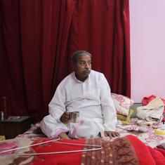


“Imagine this. Your palm is the region of Jaisalmer and the slope that reaches the centre of your palm forms the khadeen,” farmer Chhatar Singh tells Mongabay-India, explaining how the traditional rainwater harvesting system of western Rajasthan works.
The arid tableau in the Jaisalmer district of Rajasthan seems flat from a distance. The district receives an annual average rainfall of 217.12 mm and according to the Central Arid Zone Research Institute, the western margin of the district receives less than 100 mm of annual rainfall.
However, the farmers have harvested the limited rainwater with an indigenous technique that has worked for thousands of years and helped them irrigate their fields. With this ancient irrigation system of the desert, called khadeen, farmers grow crops such as wheat, gram, mustard, and vegetables and fruits.

“The word khadeen is believed to have originated from ‘khadd’ in Sanskrit which means ‘a depression in the land’. In this depression, the water from higher levels flows and gets stored in relatively lower levels,” shares Mahesh Kumar Gaur, Principal Scientist, Central Arid Zone Research Institute, Jodhpur.
Just before the onset of monsoon, strong sandstorms accumulate sand at some spots. The farmers create embankments with this sand in the lower elevations, to create khadeens. When the rain arrives, these embankments channelise and help store water. The rainwater swells up and then percolates, from one to 10 metres below the ground, which takes one-and-a-half months to two months. The upper earth then becomes muddy. It is in these muddy waters that new seeds are sown for the crops.
Local communities say that a khadeen is never irrigated artificially, clouds alone do the work. Farmers also claim that they have never used any chemical fertiliser or urea in the khadeens and that the produce is organic.
History and culture of khadeens
Khadeens in Jaisalmer could run up to thousands of bighas (one bigha = 0.62 acres in Rajasthan). Lanela, one of the largest khadeens is spread over 3,000 bighas. Farmers from over a dozen villages accommodate themselves to grow crops here. Likewise, Jajia, a khadeen in western Jaisalmer spans over thousands of bighas. Some are relatively smaller as well, such as Bada Bagh Khadeen (100 bighas), that belongs to the royal family of Jaisalmer.
“Khadeens saw a major boom in the 14th and 15th centuries when communities from Pali and Marwar arrived here. They either rejuvenated the existing khadeens or formed new ones,” says Parth Jagani, a local conservationist who was the former caretaker of Bada Bagh Khadeen.
“There are over 650 Khadeens in Jaisalmer,” says OP Mali, a former official at the Rajasthan government irrigation department, adding that “not all of them are functioning presently”.

But how does one identify which parcel of land could be turned into a khadeen?
Singh responds, “The land itself conveys that message. Also, wild camels help in that process. They know where plants with good fragrance exist and once we follow them, we know our land.” When you find local plants growing naturally without any intervention, it would mean that the land is already fertile and could be used for making khadeens, he said.
To grow crops in a khadeen, the community members work together to sow the seeds, guard the crops and harvest. Some farmers even stay in the khadeen until the harvest time, to protect the crops.
The first fistful of grain is gifted to the gods and the subsequent shares are offered to widows, the elderly and the disabled and other vulnerable groups first. The farmers tell Mongabay-India that they don’t sell the produce at the market, except in rare cases. They distribute all produce among themselves, for their own consumption. In fact, a certain harvest percentage is fixed to share among the community members and this number varies from one khadeen to another.
The hydro-geology of the khadeens helps in water percolation. The rocks here were formed 252-66 million years ago, in the Mesozoic age. Granite, gypsum and other semi-porous stones don’t let rainwater percolate much deeper, thus reducing the gap between the roots and water.
“The perched water table condition occurs at shallow depth in clay beds and kankars which arrest the rainwater,” reads a report by the Ministry of Water Resources, Central Ground Water Board.
When the water flows from higher elevations, it brings with it a sheet of silt (rich in manure) that covers the khadeens like a blanket and reduces evaporation. The xylem of the plants’ roots receives nutrients and other minerals from the percolated underground water.
Apart from wheat and mustard, Gaur of the Central Arid Zone Research Institute says he believes that the farmers could also be trained to grow fruits, such as pomegranate, and other leguminous plants, keeping in mind the indigenous value systems. “They could also be trained to adapt to the climate crisis, which is hampering production,” he adds.

Khadeens as wetlands, drinking water sources
During the monsoons khadeens become natural wetlands. Winter migratory birds make these harvesting structures their temporary home. In Bada Bagh alone, conservationist Jagani has counted over 138 species of birds including painted storks, demoiselle cranes, common cranes, bar-headed geese, knob-billed duck and lesser whistling ducks, among others. He has also noted 38 varieties of butterflies and four species of bees.
Ber (Ziziphus mauritiana , also known as Indian jujube), khejri (Prosopis cineraria) and desi babool (Acacia nilotica) are the three main trees found in this khadeen. “We also have mango, jamun, maulsari and other trees. Also, the leguminous trees help khadeens fulfill their nitrogen shortage,” Jagani says.
A khadeen is also integral to the availability of drinking water for the villages. Beris or small wells are dug in these khadeens and each khadeen could contain many beris. “About 3,000 to 4,000 people drink water from these beris during the harvest time,” farmer Prem who works at Lanela Khadeen tells Mongabay-India.

The impact of infrastructure development
Khadeens, however, are not isolated from the threats to wetlands in the country. A large part of Jaisalmer is covered by canal irrigation. The government’s census projected that “the existing pattern of economy in this desert region was expected to be completely transformed” with the construction of the Indira Gandhi Canal, initially known as Rajasthan Canal, the longest (625 km) in India.
“The canal indeed transformed the region. However, it hardly served any good to khadeens. It brought water to other regions in Rajasthan, prompting farmers to ditch the khadeens and migrate to areas irrigated by canals, as canal irrigation promised them more production,” shares Singh.
“First, the people left the practice and then the stone-mining was started, which altered the water bodies’ catchment area. Thus, the khadeens were destroyed. Their embankments (dhaura or baandh) broke, channels (naala) stopped, and knowledge became restricted,” he tells Mongabay-India.
Jajia khadeen will be alive only till the next decade, as its catchment area has already been allotted for mining, says a worried farmer Manohar Singh who cultivates gram there. “Somehow, water is finding its ways to reach this khadeen, but the flow is impacted. Rainwater is having difficulties reaching the end of the khadeen. It stops somewhere in between, hampering cultivation [to a large extent],” he adds.
 of a khadeen. Credit: Amir Malik/Mongabay.")
The government of India in its last census report stated, “irrigation on any significant scale, is impracticable” in the district. It adds that “minor irrigation is, however, possible from the tanks locally known as ‘Khadeens’ where in the rainy season rainwater flows from their catchment areas into these tanks.”
Seven tanks were constructed or renovated during 2009-’10, according to the census data. However, a khadeen is not a small “tank”. It’s a large area of land where water is harvested and crops are grown.
The net area irrigated by canals in 2010-’11 was 58,860 hectares compared to area irrigated by wells which was 42,469 hectares in the same year. The latter includes khadeen irrigation but fails to specifically mention what percent is irrigated by khadeens. The total area of the district is 3,839,154 hectares as reported in the year 2008-’09 to 2010-’11. It’s spread over 38,401 sq kms. Of this, the area occupied by khadeens is not recorded.
Also, there has been no scheme since 2005 directed towards the revival of khadeens, Mali notes. “Through some other employment schemes such as the Mahatma Gandhi National Rural Employment Generation Scheme, the people might have received a small amount by working in khadeens, but the government has not done anything concrete so far to restore, renovate or revive khadeens,” he explains.
Reviving an ancient practice
To fix the dent in the ancient wisdom, 40 years ago, Chhatar Singh decided to dedicate his life to revive khadeens and has not looked back since. With the support of local communities, he has helped revive hundreds of khadeens, including Bada Bagh.
“We don’t oppose development, but never should it cost the indigenous ways of life, like it did here,” say Chhatar Singh and other farmers.
Singh and his team first divide the large khadeens into smaller pockets. “When water flows from one pocket to the other, it looks like a snake walk,” Raga Ram, a farmer from the Bhil tribe from Ekalpar, about 70 kilometres from the city, tells Mongabay-India.
In recent times, it is the Bhil tribe that has been supporting Chhatar Singh to revive khadeens. “We didn’t want to migrate for work and Singh encouraged us to revive the khadeens to help both ourselves and the environment. Thus, we started reviving [these] khadeens,” Ghazi Ram, another farmer from Bhil tribe adds.

On windy summer days, the sand flows like water, in Jaisalmer and the most important feature in a khadeen, for it to work successfully, is its bank. The embankment (baandh) made from the flowing sand must be strong. The khadeen resurrectors build a concrete wall about 4.5 feet tall; this wall is known as pankha, locally. It protects the baandh. Adjacent to the pankha is another smaller wall, chadar (shorter than the dhaura or baandh) from where water exits to enter the next pockets.
Over 200 beris have been revived which now have year-round drinking water. These wells have stored water, two to 20 feet under the ground. This water is locally known as rejwani pani or hidden water. Several other wells (other than beris) and big ponds and lakes (palar pani) have also been cleaned and revived.
“This year, we will revive 40 more khadeens in Jaisalmer, for which the work is already going on,” Chhatar Singh exclaims proudly, as he walks in a revived khadeen full of mustard plants that stand taller than him.
This article was first published on Mongabay.