

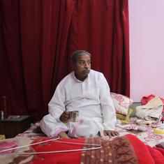


Hassan Sab did not expect to lose land twice. Standing on Kasarkod beach, in Karnataka’s Honnavar taluk, Sab pointed out to the Arabian sea. There, he explained, “my family owns three acres of land. It was accessible till about four decades ago”. Over the years, however, the mouth of the river Sharavati, which met the sea near their village, Mallukurva, shifted northwards, submerging the village. By the mid 1980s, nearly the entire village was underwater, and most of its residents had relocated.
But after a decade, the sea began to deposit sand back towards the south, and created a sand pit approximately three km long and 600 metres wide, close to where Mallukurva lay submerged. “The sea deposited sand back on the Kasarkod side of the river,” Sab said. “At some places it was only a few 100 metres away from my original village, at some it was about a kilometre away.”
The former residents of Mallukurva believed that the newly emerged land was part of their old village.
“There is no other way about it,” Sab said. “Mallukurva was submerged, and now if land is reappearing close to its original location, it has to be Mallukurva.”
But as information on the state government’s website on land records makes clear, the revenue department treated the newly emerged land as part of Kasarkod, and named it Tonka, the Konkani word for tip or tail.
This was the mid-1990s, a time during which the number of trawlers and persin boats in the region’s sea waters were increasing, and with this, the amount of fish being landed on the coast. Surplus after fresh sales was also growing – the only way to store this surplus for later sale was by drying it. Since there was now an increased need for space for drying fish, Sab and over 150 other locals, who belong to the fisher community, began to use the newly formed land. “We divided land among ourselves,” said Sab. “We used natural identification marks on the river bank, such as a mango tree, light house and the bridge to identify approximate boundaries of our individual land shares.”
Locals built temporary shelters and other facilities on the land, and began to spend the months between October and May every year on it. “We needed to stay on the land during those seven months to guard the fish against stray animals, and change fish angles on the line,” Sab said. “We would cook, eat, sleep and wake up there.”
But in 2016, the Karnataka Public Works, Ports and Inland Water Transportation Department sent eviction notices to around 60 of these seasonal migrant families, including Sab’s, stating that the land they were using belonged to the department.
Sab and 27 others approached the district court, challenging these notices.
The court directed the district collectorate to conduct a survey to determine who owned the newly emerged land. The survey concluded that the land belonged to the port department, and that Sab’s land now lay under the sea, 1.2 km away from the newly formed sand pit.
A year-and-a-half later, the district collector ordered the demolition of all structures that had been built on the newly formed land, including fish-drying sheds, temporary shelters and other facilities that belonged to the families. Soon after the order was issued, the port department cleared the area of all these structures.

The department then built a wall on the land to mark out a compound; it also began constructing a coastal road using part of the land, linking it to the nearest highway. Fisherfolk raised objections to the road project at local government offices, and filed a petition against it at the National Green Tribunal. They argued that the area was a turtle nesting site, and was thus ecologically sensitive. Further, they argued that the port department had not obtained clearance from the state’s coastal zone management authority before starting the road work. The department argued that in 2013, the newly emerged land had been notified as a port area under the Indian Ports Act, 1948, and that this classification placed it outside the purview of laws that limit construction activity in coastal areas. In September 2023, the National Green Tribunal ruled in favour of the department and disposed of the petition.
The loss of Mallukurva and the accretion of new land near the village is part of a much broader phenomenon of coastal erosion, which affects all of India’s coast, and is particularly pronounced in Karnataka. Between 1990 and 2016, India lost 235 square kilometres of land to coastal erosion, of which, 28%, or 66 square kilometres, fell in Karnataka.
Researchers predict that such erosion in coastal Karnataka will intensify. “Warmer temperatures are leading to stronger and wetter storms,” explained MD Subhash Chandran, an ecologist at the Indian Institute of Science, Bengaluru, and a member of the Karnataka Coastal Zone Management Authority. “These, combined with sea level rise, lead to more destructive storm surges with unusually high tides that can cause coastal flooding. Due to sea level rise, the waves can go further inland on beaches and erode them.”
The change in the coastline is already quite stark: one study of changes in coastal land between 1990 and 2016 found that more than 22% of Karnataka’s 300-km coastline was “under erosion”.
Residents of villages like Mallukurva experience further distress and confusion as a result of conflicts over new land formed by material deposited by the sea. The phenomenon is not unique to the village: government reports note that between 1990 and 2016 India gained 231 square km of land through a similar process of accretion.
But, Indian policymakers have yet to fully address these complex problems that result from the interplay of coastal erosion and accretion. In 2021, the 15th Financial Commission Report recommended that the Centre and state governments “develop a policy to deal with the extensive displacement of people caused by coastal and river erosion”. Soon after, in 2022, the National Disaster Management Authority announced a draft policy for the rehabilitation and resettlement of those displaced by erosion. The proposed policy does not address the question of accretion, but acknowledges the need for mitigating erosion and rehabilitating people displaced by it. It also recommends that affected communities be consulted on these matters, and that displaced households should be granted ownership of land to which they are relocated, along with a comprehensive rehabilitation package. The policy, however, remains in draft form, and is yet to be finalised.
This story is part of Common Ground, our in-depth and investigative reporting project. Sign up here to get a fresh story in your inbox every Wednesday.
The problem of erosion is particularly acute in Honnavar due to the presence of the Sharavati. The river flows through the Western Ghats, feeds the famous Jog falls, and forms several fragile ecosystems along its course, including swamps and grasslands. It also forms nearly 150 islands that are home to critically endangered vegetation and wildlife, including Kanara nutmeg and the lion-tailed macaque.
While the river basin supports rich biodiversity, development planners view it chiefly as a source of power. A 2012 government report notes that the “steep and undulating terrain of the region” made it ideal for hydroelectric power generation. Indeed, as of December 2022, over 40% of installed hydropower in the state was generated in the Sharavati basin.
The report notes that the slew of development projects on the river have changed the natural flow of the water. Multiple studies have also linked the shifting of the river’s mouth with the construction of dams on it.
The first major project in the river basin was the Hirebhaskara dam, built across the river in 1932. Dr Prakash Mesta, a marine biologist and an expert in GIS mapping based in Honnavar, who has studied erosion in the region, explained that land on the river banks near Honnavar and Karki, villages witnessed significant erosion right from this time.
Other projects were constructed on the river in subsequent decades. These include the Linganamakki Dam, whose reservoir, built in 1964, submerged the Hirebhaskara dam and over 300 square kilometres of biodiverse forests. Another major project was the Honnavar bridge, which was initiated in 1959 by the Central Public Works Department over the Sharavati, and which has connected Honnavar with Kasarkod since its completion in 1971. In the 1980s, further erosion was caused by the construction of the Gerusoppa dam, also known as the Sharavati Tail Race project.
“Such development projects alter the water flow and disrupt the natural sedimentation process,” said Dr TV Ramachandra, a scientist in ecology and energy, and coordinator of the Energy and Wetlands Research Group, at the Indian Institute of Science. In the Sharavati’s case, he explained, the river’s mouth has gradually shifted northward, while its estuary region has seen increasing deposits of silt from the sea. “Having nowhere to go, the estuarine water moves inland during high tide and causes erosion,” he said.

As a result of these processes, the river’s path has shifted considerably. “Sharavati used to be about 2 km away from Pavinakurva village,” said Mesta. Now, he added, it had begun to erode the village itself.
The shift in the course of rivers is not an unusual phenomenon – oceanologists attribute such changes to the earth’s rotation, but they typically estimate any measurable shift to take place over a period of centuries or at least decades. With the Sharavati, the change has been rapid, observable even over a period of a few years.
These changes have had profound effects on the region’s geography and ecology. “Earlier, the river used to be more active during monsoons,” said Ramachandra. “The tidal water would reach up to Gerusoppa village, which would support mangroves in the post-monsoon months.” Mangroves are crucial for coastal communities as a first line of defence against the sea during storms, as well as to protect land from erosion.
Dam reservoirs release water regularly and have thus done away with this seasonal change, leading to a deterioration of mangroves. “Now the river has a constant flow,” he said. “Saline water doesn’t reach the mangroves anymore.”
Despite the growing magnitude, intensity and severity of impact of erosion on coastal communities, coastal erosion is not officially considered a natural disaster at the national level. This gap is apparent at the state level as well. The Karnataka state disaster management policy doesn’t list erosion as a natural hazard, while drought, flood, landslides, cyclones and earthquakes are listed as such.
In the absence of national and state guidance, local government and district-level authorities have responded to erosion-induced destruction and displacement in an arbitrary manner. Honnavar is a case in point.
Mesta, who has been working with the fisher community over decades on issues of erosion, wildlife protection and their rights, noted that the first major instance of which he had learnt, of damage caused to villages by floods, dated to the early 1960s. These floods damaged around 120 houses from Mallukurva and 40 from Honnavar town, he said. “At the time, those displaced were allowed to resettle in Kasarkod,” said Subray Naik, a 74-year-old resident of the village.
The first available documentary records of compensation or resettlement for those displaced by erosion date to late 1977. That year, when a massive flood in the Sharavati caused severe damage in Mallukurva, Karki and other nearby villages, the government allotted land to some of those who were affected.
But last year, locals told Scroll that those who had been resettled had not been issued ownership documents for their land.
“Most of the flood-affected people from Karki village were given forest land nearby,” Mesta said. But, he added, “till today the land titles have not been awarded in the name of flood-affected families”.
In the case of Mallukurva, those displaced received land in Kasarkod village. According to a 1977 order by the Public Works and Electricity Department of the Government of Karnataka, 24.5 acres of land from Kasarkod were transferred from the port department to the revenue department, to be allotted to between 300 and 400 families displaced from Mallukurva. However, some of these resettled residents told Scroll that the land had still not been registered in their names.
Scroll emailed Nagaraj Nikad, tahsildar at Honnavar’s revenue office, to enquire about the status of these land registrations, but as of publication, had not received a reply.
Meanwhile, the sea and the river continue to eat away at villages in the region. Vinod Patgar, a local environmental activist and resort owner, noted that every year, between one and two acres of land were eroded or submerged under water. Residents and former residents of Pavinakurva explained that families typically waited till the danger of the sea and the estuary became too great to ignore, after which they shifted out of the village, usually without government assistance.
In Pavinakurva, fisherman Budhvan K Mesta once owned 17 guntha, approximately 0.4 acres, of land and is now left with just 13. “The river ate four guntha over the last 30 years,” he said. Pavinakurva is also affected by sea erosion. “The beach is closer now,” Mesta said. “Earlier it was a kilometre away, now it is a few 100 meters away.”
Scroll met Kiran Kumar, the Panchayat Development Officer at Karki Gram Panchayat under which Pavinkurva village falls, to enquire about the rehabilitation of people displaced from the village. Kumar insisted that that the government had acted to help affected families: flipping through a register, he stopped at a page with information for 2004, and noted that that year, 72 families had been identified for resettlement. He added that a total of three acres and 11 guntha of land had been identified in Karki for this.
But those who had been displaced told Scroll that the land that was issued to them was not sufficient or habitable. Among them was Usman, a fish trader who lost 17 guntha of land in Pavinkurva in the 1980s – the remains of his house, destroyed by the river, can still be found near the estuary. “I wasn’t allotted land but my brother was offered land as compensation,” said Usman, who asked to be identified by a pseudonym. But, he added, the land allotted was “on a hilly area and filled with boulders”. Because the land was far from the coast, and would have required immense resources to level, Usman’s brother did not settle on it.

According to Mesta, while river erosion had ceased for now, the sea was inching toward Pavinakurva. In 2011, only three years after the last households moved from Mallukurva, 13 families were forced to resettle from Pavinakurva too, according to news reports.
Others had seen the warning signs and left much earlier. “By 1988 the waves started approaching closer to my house,” said Paresh Tandel, 60, who asked to be identified by a pseudonym. “I knew then it was time to move.” Tandel shifted to Tonka, but still owns 22 guntha of land, around 0.5 acres, in Pavinakurva. “In the following 15 years, 15-20 families moved here,” he added.
Those who stayed on lead precarious lives. “The nights when it rains heavily and the sea is furious, we take our important papers and valuables and leave the house,” said Saroja Pevankar, whose family owns two guntha of land, around 0.05 acres, in Pavinakurva village, on which they live with a cow and calf and grow coconuts. She added, “We come back in the morning to tend to our cow and the calf.”
The inadequacy of the government’s response is also evident from its emphasis on seawalls. A 2020 report by the Central Water Commission noted that seawalls have been the most commonly used method to tackle coastal erosion in India.
Solutions to combat coastal erosion fall into two categories: “hard” ones, typically structures such as seawalls and breakwaters, and “soft” options, such as beach nourishment and sand dune restoration. The annual reports of Karnataka’s Public Works Department, and Port and Inland Water Transport Department, viewed by one of the authors, reveal that between 2017 and 2021, the government spent more than Rs 190 crore along the Karnataka coast to protect beaches from coastal erosion.
But a recent Intergovernmental Panel on Climate Change report advises against seawalls, noting that though they may be found effective in the short-term, in the long run they “can increase exposure to climate risks unless they are integrated into a long-term adaptive plan”. Other studies have also have advised against building seawalls.
Yet seawalls are the solution that locals, elected representatives and government authorities view as a “quick fix to check the water ingress”, said Aditya Valiathan Pillai, fellow at the Sustainable Futures Collaborative at the Centre for Policy Research, New Delhi.
He added, “They can be erected in months unlike the soft measures, which take much longer. They can pacify communities that have suffered repeated erosion and demand rapid government action to prevent further loss of property.”
Community members and experts from Honnavar have also criticised seawalls, arguing that they don’t provide long-term solutions and in fact, create new problems. “They only shift the wave dynamics to other coastal stretches, accelerating the rate of erosion there,” explained coastal ecology specialist VN Nayak. “It is a substantial wastage of budgetary allocations.” Locals too have realised the futility of seawalls. “Such artificial structures have been constructed for over three decades, repeatedly on the same spot, as they often collapse against strong waves,” said Patgar.
In Pavinakurva, less than 50 metres from Budhvan K Mesta’s house is a seawall, intended to protect the village from sea erosion. In mid-May 2023, the structure was just a mass of scattered rocks.

Meanwhile, the National Disaster Management Authority’s draft policy suggests that to control coastal damage, construction rules laid out in coastal regulation zone notifications should be adhered to. But these rules themselves were changed in 2019 to allow for construction closer to the sea. A new notification that year reduced the distance from the high-tide line in within which no development was allowed, from 200 metres to 50 metres. This has made way for more constructions closer to the sea.
Amalendu Jyotishi from Azim Premji University’s School of Development, believes that policy and planning derived from local knowledge with the active participation of local communities can effectively address these complex challenges. He noted, for instance, that locals could “provide useful information on how far the water reaches inland during high tide, where a seawall would work and where plantation could be effective.”
Patgar observed that if the government failed to consult communities, it could result in poorly conceived solutions to erosion. “The government makes sea walls where they deem fit, without finding out if it is a boat parking area, or if it harms the fishers in any way,” Patgar said.
Ramachandra Bhatta, Scientist Emeritus of Mangaluru’s College of Fisheries, an expert in environmental economics and governance, argued that acknowledging the limitation of seawalls was the first step.
“Demarcate beach areas of Honnavar, Kasarkod and Karki as high-eroding areas and put an immediate stop on construction activities there,” Bhatta said. He added, “This should be followed by soft engineering techniques such as beach nourishment and development of green belt.”
Beach nourishment entails artificially increasing available sand on a beach using sediment obtained from dredging work at places such as port and jetty construction sites. But this method can become unmanageably expensive and unsustainable, especially in areas that see strong waves, or where sediment is moved rapidly by water.
The other alternative suggested by Bhatta involves planting vegetation on the shore that can hold sediment in place and reduce the intensity of waves. Plants such as coconut, beach morning glory and cashewnut are among those that can be used to protect shoreline from erosion in this way.
Revegetation, as the process is known, is considered to be particularly appropriate in estuarine areas, such as Honnavar, compared to open coasts. The relatively calmer waters, “low energy environment”, and the presence of greater nourishment due to the mixing of sea and freshwater helps ensures the survival of the vegetation.
In fact, Karnataka’s Public Works Department, and Ports and Inland Water Transport Department, with the support of Asian Development Bank, is implementing a coastal protection project based on soft measures in Pavinakurva. It includes reconstruction of natural dunes on the coast, and planting of endemic plants to stabilise the dunes through community participation. However, according to locals, the work is yet to start. Scroll emailed the member secretary of the Public Works and Ports and Inland Water Transport Department about the status of the project and activities undertaken – as of publication, he had not responded.
For now, locals worry for their future given the fast-eroding coast, uncertain status of their lands and government reluctance in letting the fisher community use the accreted land.
“The government should issue land ownerships to fisherfolks who were displaced during the 1977 flood,” said Rekha Tandel, a local fisherwoman. “They have got the papers to prove that the government allotted them land. Let us use the land created by the river. And all developmental activities such as road construction, port, breakwater and dredging should be stopped to control rapid erosion.”
The story was supported by the Earth Journalism Network’s Coastal Resilience Story Grants 2023.