


On his trip to Ladakh today, Prime Minister Narendra Modi will visit the Siachen glacier to meet troops stationed there. At 6,300 meters above sea level, the glacier is the site of the world’s highest and coldest conflicts: India and Pakistan have faced off against each other there since 1984. More than ten years after a ceasefire was been declared, India still maintains about 3,000 troops at these dizzying heights.
Here are five charts about battleground Siachen.
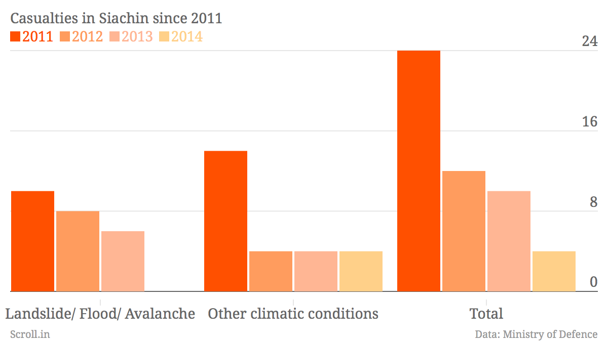
The Indian army went into Siachen in 1984 during Operation Meghdoot when it established control over the glacier. In the 30 years since then, India has lost more than 1,000 troops in the area.
There have been more deaths on Siachen due to the harsh environment and extreme temperatures than due to battle. The number of casualties has dropped since the ceasefire in 2003.

Estimates of casualties on the Pakistan side are similar to the losses in India. A particularly bitter blow to Pakistan was an avalanche in the Gayari sector of the glacier on 2012 that killed about 150 soldiers.

Both sides have spent many billions of rupees in maintaining troops in the high-altitude warzone. The costs include building infrastructure, developing suitable high-altitude clothing and even on food research to produce special nutritious foods with a longer shelf life.

There have been many calls to demilitarise the Siachen glacier since the Gyari avalanche. Some environmental experts believe that the large military presence is hastening the glacier’s melt. Others studying Siachen say it is one of the Himalayan glaciers that is actually advancing. One of the most widely cited studies on the Siachen glacier finds that it advanced in the 19th century, retreated between 1930 and 1960 and then stabilised.

We welcome your comments at
letters@scroll.in.
Here are five charts about battleground Siachen.
The Indian army went into Siachen in 1984 during Operation Meghdoot when it established control over the glacier. In the 30 years since then, India has lost more than 1,000 troops in the area.
There have been more deaths on Siachen due to the harsh environment and extreme temperatures than due to battle. The number of casualties has dropped since the ceasefire in 2003.
Estimates of casualties on the Pakistan side are similar to the losses in India. A particularly bitter blow to Pakistan was an avalanche in the Gayari sector of the glacier on 2012 that killed about 150 soldiers.
Both sides have spent many billions of rupees in maintaining troops in the high-altitude warzone. The costs include building infrastructure, developing suitable high-altitude clothing and even on food research to produce special nutritious foods with a longer shelf life.
There have been many calls to demilitarise the Siachen glacier since the Gyari avalanche. Some environmental experts believe that the large military presence is hastening the glacier’s melt. Others studying Siachen say it is one of the Himalayan glaciers that is actually advancing. One of the most widely cited studies on the Siachen glacier finds that it advanced in the 19th century, retreated between 1930 and 1960 and then stabilised.