


Along the northern border of the Valmiki Tiger Reserve in Bihar, a slightly raised cemented road leads to Chakdahwa, a small village some 55 km from Bettiah, the district headquarters of Pashchim Champaran. A unit of the Sashastra Seema Bal, a paramilitary police force under the Union Ministry of Home Affairs, is positioned there, indicating nearness to the India-Nepal border.
Slightly ahead of Chakdahwa, the cemented road abruptly turns into a kuccha stone-paved road signalling the arrival of Susta, a disputed village on which both India and Nepal stake a claim.
“Chakdahwa is in India, but Susta is a disputed territory,” said a Seema Sashastra Bal guard posted in Chakdahwa.
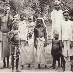
The residents of Susta, which comprises over 265 families, claim they are part of Ward 4 of Triveni Susta panchayat in Nawalparasi district of Nepal. “Susta has always been a part of Nepal and we are Nepali,” said Aurangzeb Khan, vice-principal of the Shri Janta Dalit Primary School, the only school in Susa, whose painted wall reads Nawalparasi, Nepal.

The people blame the changing course of the Gandak river, known as Narayani in Nepal, for the controversy around Susta. “Gandak forms the international boundary between Nepal and India [Bihar]. said Khan. “Earlier, Susta was on the right bank of the Gandak, which falls in Nepal. But, in due course of time, the river has changed its route and Susta now falls on the left bank of the Gandak, which is controlled by India. Should the changing course of a river change the nationality of local residents?”
Treaty of Sugauli
There are no easy answers to Khan’s question as the Susta controversy dates back to the early 1800s, when the British ruled India. The Anglo-Gurkha War took place from 1814 to 1816, culminating in a treaty between Nepal and the East India Company in March 1816.
Known as the Treaty of Sugauli, it led to the demarcation of the international boundary between India and Nepal. Another Supplementary Boundary Treaty was signed in December 1816 to settle the border dispute.
The boundary line between both countries was surveyed and demarcated from 1816 to 1860, from 1882 to 1885, in 1906, and from 1940 to 1941. Boundary pillars were placed at a distance of 1 km to 2.5 km, reads a paper, “The natural environment and the shifting borders of Nepal”, authored by Buddhi N Shrestha, former director general of the Government Survey Department, Nepal. Strip maps were prepared for border demarcation.
However, during demarcation, both the sides had several disputes. In some places the border areas were inaccessible, such as the Gandak river, so no border pillars were erected there. This left enough room for future disputes, which both countries are trying to resolve even 200 years after the signing of the treaty. There are estimates of 60,000 hectares of disputed border land between India and Nepal.
A river and a border
The Gandak river, also known as Sapt Gandaki and Narayani in Nepal, originates at the Nhubine Himal glacier in Nepal. It flows across Nepal and enters India near the Valmiki Tiger Reserve in Bihar, from where it flows down another 300 km to meet the Ganga near Patna (see map).

The 1816 treaty took the Gandak as the international boundary between India (Bihar) and Nepal. The right bank of Gandak came under Nepal’s control, and the left bank became Indian territory.
At the time the treaty was signed, Susta was on the right bank of the Gandak and a part of Nepal. But, over the years, the Gandak changed its course and Susta moved to the left bank, that is, on the Indian side of the river.
“An area of some 5,000 acres [approximately 2,023 hectares] of land in Narsahi-Susta area adjoining the Gandak river in West Champaran district has been encroached upon by Nepalese nationals. There is a difference of perception of the boundary alignment between India and Nepal in this area due to shifting of rivers...,” is how the then Union Minister of External Affairs answered a question in the Lok Sabha in 2002.
Shrestha, however, alleged that over 14,860 hectares of Nepali land in Susta has been encroached upon by India.
Both the countries are trying to resolve the matter, but Susta remains a bone of contention. In a July 2014 interview, Union Minister of External Affairs Sushma Swaraj said that “98% of our boundary with Nepal has already been agreed” but we need to provide “a political impetus to resolve the remaining issues”.
In 1981, a Joint Technical Level Nepal-India Boundary Committee was set up, which after years of surveying and deliberations delineated 98% of the India-Nepal border on 182 strip maps. But, Susta was not part of this delineation.
In 2007, these strip maps were presented to both countries for ratification. Nepal refused to sign the documents without resolving the Susta and Kalapani disputes (the Kalapani row is over a 35 square km disputed area where the border is marked by another river, the Mahakali). India, too, did not endorse the maps.
Three years ago, India and Nepal set up another boundary working group at the level of the surveyors-general to settle the border issues. But, there has not been any breakthrough.
Nepal maintains the Gandak’s course in 1816 to be taken as the fixed international boundary. India believes that land on the left bank of the river is its own territory.

Gandak’s shifting course
Research shows that Himalayan rivers keep changing their courses every now and then, thereby throwing up new territories and submerging old land. “Because the river dissolves old lands and creates new ones, the new lands are ‘illegally’ occupied by people beyond the border. So, what was once Nepalese territory is occupied by Indians and vice versa,” reads a 2009 paper by Pushpita Das, research fellow at the Institute for Defence Studies and Analyses, New Delhi.
According to Dr Medha Bisht, assistant professor, department of international relations, South Asian University, New Delhi, “The existing bilateral treaties have not taken the shifting of Himalayan rivers into consideration. A primary reason for this is the lack of eco-system approach where often ecological concerns and needs of the river are dismissed.”
In his 2006 paper, Shrestha claimed that the Gandak river was shifting east to west on the India-Nepal border. “Every time the Narayani [Gandak] river, which separates India on the east and Nepal on the west, cuts its banks on the west… the Nepalese territory gradually shifts inside India as encroachment. There are big floods and thousands of hectares of land shift towards the east of the river all at once,” he wrote.
During each heavy flood – 1845, 1954, 1972, 1980 and 1989 – the Gandak changed its course, leaving Nepali land on the east of river (that is, in India), he has claimed. In this process, Susta has moved from the right bank of the Gandak to the left bank in India.
But, loss of land to the Gandak is not limited to Nepal alone. “In the last 10 years, in a significant stretch of the Valmiki Tiger Reserve, just downstream of the Gandak barrage on the India-Nepal border, some 300 metres to 400 metres of forest has gone into the river,” said Samir Kumar Sinha of Wildlife Trust of India, who has been working at the tiger reserve since 2003. “There is no regular documentation of such loss.
Divided opinion

Expert opinion on Susta is divided. “In international law, the principles of avulsion and accretion are applicable to determining the border when a boundary river changes course,” said Brahma Chellaney, professor of strategic studies at the Centre for Policy Research, New Delhi. “If the change of the river course is rapid – by avulsion – the boundary does not change. But if the river changes course gradually – that is, by accretion – the boundary changes accordingly.”
Since the Gandak’s course changed by accretion, the India-Nepal boundary must reflect the river’s current course. So, the village [Susta] falls in India, he added.
Medha Bisht of the South Asian University has a different viewpoint. “As per the international case law, the original course of the river would be taken as the boundary, that is, the centre of the old river channel will be the reference point for the boundary. The new course will not be taken into account,” she said.
Lokesh Kumar Singh, district magistrate of Pashchim Champaran, refused to comment, saying Susta was “an international matter”.
Repeated efforts to seek a clarification on the Susta dispute from the Union Ministry of External Affairs failed. Gopal Baglay, official spokesperson and joint secretary at the ministry, did not respond to phone calls and email.
Caught in the crossfire
While India and Nepal try to resolve the dispute bilaterally, the residents of Susta express a strong need for closure. “We have been tilling this land for generations, but not anymore,” said Aurangzeb Khan. “Every now and then, there are skirmishes with Indian farmers.”

Villagers complain that during the monsoon, it is a fight for survival. “We are just a kilometre away from the Gandak. Every monsoon, Susta gets inundated and we have water till our chest level,” said Noorjahan Begum.
Officers on the Indian side, on condition of anonymity, claimed that several residents of Susta indulge in illegal practices, such as timber felling, cane smuggling and poaching. Since Susta is a disputed territory, it is a safe haven for anti-social elements, they said.
Bisht recommended that an alternative dispute resolution mechanism within the ambit of existing treaties should be deliberated upon by the concerned countries. “Where such a mechanism is non-existent, frameworks for such a forum should be negotiated,” she said. “This will not only help in de-politicising disputes, such as the current one in Susta village, but will also be beneficial for Indian diplomacy in the long term.”
Meanwhile, Chellaney reminded both India and Nepal that rivers are prone to changing course. And, the Gandak might change course again.

Nidhi Jamwal is an independent environment journalist based in Mumbai. Her Twitter handle is @JamwalNidhi
All images courtesy Nidhi Jamwal