


In the 1580s, the adventurous son of a Dutch innkeeper found himself on a ship sailing from Lisbon to India. Newly employed by the archbishop of Goa, Jan Huygen van Linschoten was headed to the capital of the Estado da India Portuguesa – the Portuguese State of India – from where the European power almost completely controlled trade with the subcontinent.
Decades after Vasco da Gama discovered the sea route to the subcontinent, the Portuguese colonial empire kept its navigation intelligence a national secret and reaped the rewards, leaving the British and the Dutch desperate to learn how to traverse the long and treacherous journey themselves. But little did anyone know that the tide would soon turn and it would be van Linschoten who’d spark the beginning of the end of Portuguese hegemony in the East.

As an assistant to the archbishop, van Linschoten spent five years in Goa, learning all about its inhabitants, culture, and local life, besides the structure of the Portuguese empire and how it controlled the region. This information would go on to form the backbone of the Itinerario, a seminal book he wrote on his return to the Netherlands in 1592. Besides extensive information about the journey from Lisbon to Goa, the territories of the Portuguese empire, and sailing instructions, this book included detailed maps of the region, which were kept under wraps for so long.
Published in 1596, the book was an instant best-seller and was soon translated into English. The Dutch and the British had found the key they’d sought for so long and went on to unseat the Portuguese from the region.
More than 400 years after van Linschoten published the Itinerario, one of his historic maps is now in the possession of Prashant Lahoti, the Hyderabad-based co-founder of the Kalakriti Art Gallery. Van Linschoten’s is only one of the 5,000 old maps Lahoti owns. Others, collected over a period of 15 years, include those dating between 1482 and 1913 and sourced from eight countries. Some of these are on display at Bengaluru’s Indian Institute of Science until April 18.
A dying art
On the walls and on long wooden tables set up under a vaulted ceiling of the main hall of IISc, centuries of history unfold in hand-coloured, carefully engraved maps made by the ancient Romans, French, Portuguese, Dutch, and British, besides Indians.
From a woodcut map crafted in Germany years before the Europeans ever made it to the subcontinent to an almost 20-foot-long panel of the Ganga that looks like a work of art, the collection reveals the many different ways India’s geography has been perceived and interpreted over the years – all a world away from the drab, utilitarian Google Maps.
Of course, many of these maps were commissioned out of strategic interest by European powers with ambitions to take over Indian cities. The British in particular produced numerous maps, which, over the years, depict how they rapidly took control across the region. But in their quest to map out India’s critical contours, they also created a record of what the region looked like at the time, one that is especially valuable today. They’re so artistically made and nowhere near the mundane maps which are being produced right now.
“When you see a map, you find that every one has some part of Indian history captured in it,” Lahoti explained.
Among the Indian-made maps, he’s collected cosmological ones designed based on Jain theology, and pilgrimage maps that look more like paintings, showing the path towards sacred sites such as Shatrunjaya and decorated with elephants and human figures. One of them is so big it reaches from the floor to the ceiling.
Standing in front of these spectacular maps, it becomes all the more clear what we stand to lose as cartography dies out in an era of GPS navigation and apps that do all the work for you. But preserving and protecting these rare maps is a challenge, especially in India where heritage conservation is often an afterthought, and it falls upon private collectors to keep these historic pieces safe.
“In a few more years, a lot of them will really vanish away because Indians don’t have the right weather to preserve maps, first of all, and the second thing is we don’t have the habit of keeping (old) things with us,” said Lahoti, who stores his collection in a temperature-controlled room. “There’s no library culture in India, so that’s the reason why I feel like most of these are going to vanish soon.”
Fortunately, the Kalakriti Archives have made it easier than ever to explore the collection no matter where you are. Many of the maps have been digitised on Google Arts & Culture, and you can read about some of Quartz’s favourites from the exhibition below:
Ptolemaic India, Nicolaus Germanus (1482)
Years before Vasco da Gama arrived in India in 1498, the ancient Greeks and Romans referred to this woodcut map of India designed by a German monk named Donnus Nicolaus Germanus. The map was based on the rediscovered writings of Claudius Ptolemy, a Greco-Egyptian geographer from the 2nd century AD. While the image seems unrecognisable as India to modern viewers, if you look closely you’ll spot the Indus river in the northwest and the delta of the Ganges.

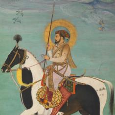
India and the Middle East, Jan Huyghen Van Linschoten (1596)
One of the most beautifully coloured maps in the collection, Jan Huyghen Van Linschoten’s depiction of India and the Middle East looks like a work of art. But there’s a fascinating story of espionage behind it. Linschoten was a Dutch merchant who managed to sneak a peek at the Portuguese administration’s secret documents and maps while working as an assistant to the archbishop in Goa. At a time when the Portuguese dominated European trade with the subcontinent, Linschoten’s map taught the Dutch and British how to traverse the long route to India, and sparked the beginning of the end of Portuguese hegemony.

Northern India, Mughal empire, William Baffin (1625)
This is the first map of northern India that almost accurately depicts the region’s geography and the spread of the Mughal empire, extending from Afghanistan and Kashmir in the north and down south to the Deccan. Made by the English adventurer William Baffin, it was based on intelligence received by the English ambassador to emperor Jahangir.

Northern India–Mughal empire, Kâtib Çelebi (1732)
This was the first map of India to be printed in the Islamic world. Published by the Turkish geographer Kâtib Çelebi in Istanbul in 1732, the map depicts the the reach of the Mughal empire with Arabic typography and what is described as a distinctively Turkish colour palate.

Plan of Pondichéry (1741)
Before the British seized and almost totally destroyed Pondicherry (now Puducherry) in 1761, it was the capital of French India and reportedly one of the finest European-planned cities in the region. Pondicherry’s broad, tree-lined streets and the key sights of the time are identified in this pink-hued plan designed in 1741.

Bengal and Bihar, James Rennell (1776)
Produced by an employee of the British East India Company, this is said to be the earliest accurate map of Bengal and Bihar and it is incredibly detailed, showing almost every village, besides rivers, mountain ranges, and even swamps. This level of detail was very intentional at a time when the company was trying to consolidate its hold over greater swathes of Bengal. The governor-general of Bengal at the time reportedly wanted the map to be a sort of “Doomsday Book” for the region, much like William the Conqueror’s revenue survey of England in the late 11th century, which was used to help register property and collect taxes. In this way, it foreshadowed the East India Company’s control over Bengal which paved the way for British control over other parts of India.

Bangalore, Robert Home (1791)
This map of Bangalore (now Bengaluru) was created after the city was captured by the British in March 1791 during the Second Anglo-Mysore war. It shows what the city looked like before Europeans began to influence Bangalore’s urban planning, depicting the walled pettah with its dense blocks divided by narrow streets. The idea behind this kind of design was to confuse potential invaders at a time when Indian cities were often attacked. Decades later, Bangalore would become a key British garrison town, and its layout would continue to change.

Bombay, Maharashtra, Juggunnath Willoba (1840)
This map showing the Bombay Harbour is one of the only surviving large-format maps of the city to have been printed in India, and was most probably produced by an Indian lithographer. The typography and bright colours are distinctively Indian, and the map was likely printed by one Juggunnath Willoba working at a printing house called Manifest Press.

Jammu & Kashmir, Thomas George Montgomerie (1850/1860)
This map marked the first time the rugged terrain of Jammu & Kashmir had been accurately recorded. As part of the massive Great Trigonometrical Survey of India, Thomas George Montgomerie was tasked with surveying the region. Between 1856 and 1860, bearing incredibly tough conditions, Montgomerie and his team scaled mountains and did extensive research on the heights of Himalayan peaks.

Plan of Delhi, Edwin Lutyens (1912)
In 1911, the British Raj wanted to move the capital of India from Calcutta to Delhi, and tasked the architect Edwin Landseer Lutyens with the ambitious task of planning the new city. “New Delhi” was to be constructed on the south and southwestern outskirts of the one-time Mughal capital, and this map shows Lutyens’s master plan, on which construction was mostly based over the next 18 years. The red lines show the network of broad boulevards that were to be built over the villages and farms that would be bulldozed. But it also shows how some Mughal monuments, such as Humayun’s Tomb, would be preserved in the new city.

This article first appeared on Quartz.