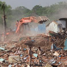
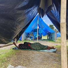
On August 7, the hillside came crashing down on a tea estate in Kerala’s Idukki district, burying a settlement. Overnight, the green, wooded landscape turned into a mangled mass of earth and roots. The body count is rising – 55, according to the latest reports, while many remain missing.
Idukki, writes journalist and author Viju B in his book, Flood and Fury, takes its name from the Malayalam word “idukku”, a place between two high spots. Narrow gorges run through this forested district in the Western Ghats. The Idukki arch dam stretches across the Periyar river, joining the Kuravan and Kurathi hills. Pettimudi in Rajamala, where disaster struck last week, is just a few kilometres from the hill station of Munnar and from the Eravikulam National Park.
Over the past six decades, the region has frequently been visited by landslides – in 2018, 2005, 1997, 1989, 1977, 1958. It is a history mapped out in tragedies, a history of climate change, deforestation and reckless building.
A changing monsoon
Scientists and researchers are yet to establish all the factors that could have contributed to this year’s landslide. But many point to the changing pattern of rainfall in Kerala over the last few years, which has led to catastrophic events.
In the 24 hours leading up to the landslide, parts of Idukki received over 200 millimetres of rainfall. In the first week of August, moreover, there had been intense rainfall in Rajmala, where the disaster-struck tea estate is located.
This is in keeping with the changing rhythm of the monsoons in Kerala, especially in the last two years. “They used to arrive at a specific time point,” said TV Sajeev, a scientist at the Kerala Forest Research Institute. “When I was in school, the day school used to reopen was the day the rains arrived – June 1. Now, it has been pushed to the first or second week of June. Then you have intermittent rains, not continuous. At the end of July until mid-August, there is high intensity rainfall.”
The spatial distribution of rainfall had also changed, Sajeev explained. “Earlier you had rain all through Kerala, now you get pockets of high rainfall,” he said. “In 2018, it was central and southern kerala. Last year, it was the northern parts. This year, it was two districts – Idukki and Wayanad. The landscape is not able withstand that kind of a downpour.”
The muddy soil of Idukki district, which lies about five metres thick above the mountain rock, comes down easily with the rain. It is one of the four most landslide-prone districts in Kerala.

The inhabitation of Idukki
But Viju points to a history of ecological devastation driven by human intervention. “The frequency of landslides started going up with human settlements,” he said. Sparsely inhabited for centuries, Idukki district saw waves of settlement between 1901 and 1991. It began with the tea plantations at the turn of the century, then the “Grow More Food” campaign of the 1940s, when forestland was turned over to agriculture.
Viju attributes the third phase of migration to the Kerala government’s policy of resettling Malayali-speaking families in this region bordering Tamil Nadu in the 1950s. In the 1970s, vast forest areas were submerged by dams – the Idukki arch dam was commissioned in 1975. The next two decades saw the growth of tourism.
Deforestation and monocropping changed the quality of the soil in some parts of the Western Ghats. “If you cut trees, the roots remain and decay, functioning as pipes which take the soil down,” explained Sajeev. “It is a process known as soil piping.” Meanwhile, plantation trees like rubber struck shallow roots, which were not able to bind the soil together. Tea shrubs, however, strike deep roots and eventually create relatively stable ecologies.
Building on the mountainside
According to Viju, landslides started acquiring a new intensity from the 1970s, first when the big infrastructure projects and quarrying started, then when the hotels and resorts spread across the hillside, spurred by the remittance economy from the Gulf.
The town of Munnar, according to scientists, shows how climate change and construction converged to create ecological disasters. “In the early days, none of the hotels had ceiling fans, it wasn’t needed,” recounted Sajeev. “Then they installed ACs. Munnar sees a major shift in temperature from summer to winter. A large number of buildings were constructed and demolished because of landslides on steep slopes.”
Modern technology had supplied the means to hack away at the mountainside. So while older, colonial roads respected the slopes, the new roads did not, Sajeev said, leading to more landslides.
August 6 saw another landslide in Munnar, this time on a national highway connecting Kerala to Tamil Nadu, destroying about 23 acres of farmland. Despite 20 smaller landslides occurring on that stretch over the past year, the road had been widened, leading to disaster.
The 2005 landslide at the Munnar Government College was blamed on “unscientific construction”. In 2018, Idukki saw a catastrophic flood after shutters to the Cheruthoni dam were opened after a spell of heavy rain. The river, which is a tributary of the Periyar, had been dry for years. But as the flood waters coursed through it, the river tore at its banks, bringing down boulders, trees and debris. Ecologist Madhav Gadgil also surmises that there might have been quarries near Pettimudi.

Ignoring the alarm bells
It was not as if alarm bells had not been sounded before. According to reports last week, Pettimudi was not identified as landslide prone. But the Gadgil report on the Western Ghats, released in 2011, classed most of Idukki and Wayanad districts as category 1 under eco-sensitive zones. In other words, they were the most vulnerable, where forest land is not to be used for agriculture or non-forest activities.
The Kasturirangan report, released in 2013, watered the recommendations of the Gadgil report. But of the 123 villages identified as the most vulnerable in the Western Ghats, 48 were in Idukki district. It still banned mining, quarrying, thermal power plants as well as the construction of buildings and townships above a certain size. Local fear about livelihood, which politicians did nothing to alleviate, meant such precautions were thrown to the winds. But ecologically sensitive zone categorisations had to be respected, urged Sajeev.
Besides, this year’s tragedy showed that the current prediction models are wholly inadequate for the new reality of erratic monsoons that concentrate their fury in small pockets of land. “ The IMD [Indian Meteorological Department] was doing district wise predictions, but now rainfall is happening at a more local level, which we need to pinpoint,” said Sajeev.
For that to happen, local populations – Dalits, Adivasis, workers who know the landscape and its ecological character – needed to be consulted. Too often, Sajeev said, they were invisible in policy making.
Which points to the sociological dimension of this year’s tragedy. Why were tea estate workers left to subsist in flimsy old houses that collapsed under mud in the first place?


