


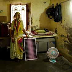

Ali was thin. His eyes had sunken in, and his cheeks clung to his face.
When I met him, he hadn’t seen or spoken to another person in over three weeks. His house was dark and dilapidated. All the windows were closed and sealed, and all the light was snuffed out. Old newspapers were stuck together and plastered onto the windows; another thick layer of duct tape held these papers together and sealed any gaps around the edges. The darkened windows reminded me of photographs I had seen from wartime Sarajevo. The borderlands had become a different kind of a battlefront.
Ali was fighting the light, and he had lived in this darkness for almost two years now. He refused to allow candlelight inside his home, so we sat in blackness. His house had nothing except a worn-down mattress, and two shirts and a pair of dark grey trousers that hung right next to the main wooden door.
Ali’s childhood friend Jamshed ran a small hardware store, and convinced me to travel with him to see Ali. He had heard from the local teacher whom I had interviewed days earlier that I was “speaking to people about the border”. So Jamshed found me at the hotel where I was staying, bringing a small plastic bag full of images of himself and his friend Ali. I told him I wasn’t a journalist, and this wouldn’t be in any newspaper.
“The border runs through him,” Jamshed told me. “You have to speak to him. You have to. He is almost gone, but I don’t want his story to be gone too. Will you write this down?”
Two days later, Jamshed picked me up early in the morning, and we drove to Ali’s house. Jamshed lives near the hamlet of Murikhawa, cradled by the river Mahananda, which acts as a natural border between India and Bangladesh here. The town of Tetulia, or the “City of Dreams”, in Bangladesh, is only 600 yards away. The Murikhawa border outpost in Jalpaiguri, West Bengal, was one of the first places to install the border fence and floodlights.
When the boundary was announced in 1947, this section of the border was forgotten and left unmarked due to an administrative oversight. Some villages that lie within Indian territory remain off the official map. Some appear as part of Bangladesh. Conversely, some villages on the Bangladesh side appear within the Indian map.
From here, we drove another forty miles east towards Ali’s house, and it took us almost half a day. We passed through three BSF checkpoints, and were stopped at each for over an hour. At the last checkpoint, the guard made the biggest fuss.
After much back and forth, Jamshed convinced the guards to let us through. I left my Nikon DSLR camera with them as collateral, and after more negotiations, a box of Cadbury chocolates I happened to have with me finalised the agreement. They would allow us to pass, but we had to return before sundown.
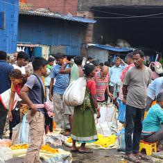
Ali lived right on the edge of the India–Bangladesh border. His village, once porous, was now almost completely sealed off and floodlit by the enormous lights on the borderline.
Once the village thrived on the cross-border markets and cattle trade, but now it was almost empty. In the last sixty years, agriculture had become unsustainable, fish disappeared from the rivers, almost everyone slid into debt, and people were forced to move because of cyclones and the constant flooding of the region.
In some cases, people moved after bouts of violence. “It gets worse each year,” Jamshed told me, as we walked towards Ali’s house. No one reports on these “small pogroms”, Jamshed said, alluding to the steady rise in violence against Muslims communities that lived there. We walked another twenty minutes down the winding road that took us past a small seasonal river. The border fence was visible from this small country road, ugly and menacing, submerged in at least a foot of marshy water.
Jamshed remarked that “all this land was once rivers and chars”, remade after every rain. Large parts of these rivers were reclaimed to build these border fences. But the men who put these fences here forgot that the river always finds its way back and, because the fences hover over soft marshes, people can easily duck under to cross back and forth.
Unlike the Punjab border, where the area was cleared of people, the Bengal border was messy. How do you remove twenty million people from their homes?
A few minutes later, I saw a floodlight emerge between the lush green trees. Jamshed pointed to one of these floodlights, and told me, “Below the light is where Ali is.” The terrain became wetter and marshier the farther we walked. The last two houses we passed before Ali’s were abandoned.
As if in a panopticon, a large floodlight stood just a few feet behind Ali’s house. The floodlights had been erected almost three years before, and the bases of these structures were already turning crimson red from the rust. Ali’s home appeared on no maps. It lay on one of the last remaining stretches of porous, unfenced international border left over from an administrative error.
There are still parts of the border where no one quite knows where India ends and Bangladesh begins. Even the BSF soldiers sent to guard these arbitrary lines often ended up on the wrong side by mistake.
Jamshed went inside to greet Ali and convinced him to come out for a bit. Ali then stepped out of his house with his hands stretched out to touch the walls for support. It took him a few minutes to adjust to the light.
Jamshed had brought his friend some local cookies, flavoured with rose water.
Ali looked famished and small. The handsome young man I had seen in Jamshed’s pictures a few days back had clearly changed.
I would compare many photographs from the past to the many people in front of me as I travelled the length of the border. Those who stood before me as I listened to their stories were vastly different from the images of themselves they showed me. The photos became an aide-mémoire to a time they could no longer return to. In those moments, the photograph became a cruel reminder of possibilities that were lost, and the people before me looked like a faded copy of their former selves violently dragged into a nightmare.
Ali managed a smile and offered to make tea. Jamshed started a fire, in the open stove on the right side of the courtyard, to boil water. We sat in silence for a while.
Ali requested that we go inside his house. “I don’t like the light anymore,” he told us. The water boiled with the loose tea leaves, sugar and milk that Jamshed had carried with him.
“What do I tell her?” Ali asked, looking to Jamshed as we sat inside his house in darkness. We finished the tea with the too-sweet rose water-flavoured biscuits as Ali recounted the first time they ate these cookies as boys.
I had got used to the dark, and I thought I saw a faint outline of a smile on Ali for the first time. Jamshed spoke, holding his friend’s hands lovingly with care. Ali mostly nodded, and sometimes managed a smile, only interrupting when he thought Jamshed had some detail wrong.
The pair told me stories from their childhood: swimming in the nearby pond, catching fish and making the first trip as young men to the nearby town to see movies.
“In the middle of the pond runs the zero point,” Jamshed told me.
The “zero point” is where Bangladesh and India meet, the official demarcation between the two countries. But this border is peculiar in that the zero point differs from where the actual border fence stands.
In 1959, a military subcommittee of Indian and Pakistani delegates agreed that, once the boundary was demarcated, neither side would “have any permanent or temporary border security forces or any other armed personnel within 150 yards” from the boundary line established by Cyril Radcliffe in the Partition twelve years earlier. The agreement between the Government of India and Pakistan was referred to as the 1959 Ground Rules, and listed a series of procedures to end the disputes and incidents along the Indo-East Pakistan Border Area.
The Radcliffe Line cut through villages, markets, rivers, farms and even houses. The border turned neighbours into citizens of different countries – India and Pakistan – in 1947. After the Liberation War of 1971, East Pakistan became Bangladesh, and these rules were confirmed again in the 1974 Land Boundary Agreement between India and Bangladesh.
In 2007, India began the construction of a border fence 150 yards from the zero point, which left substantial areas of Indian farmland, villages and families living close to the border outside of the fence. According to some estimates, 890 families are still living outside the border fencing and 200 of these are in Barak Valley, all waiting for the monetary compensation and rehabilitation package the government had promised them.
Bangladesh objected to the construction of the fences within 150 yards from the international border, alleging that the fencing and border roads violated the guidelines of the Ground Rules. Bangladesh has neither border fences nor border roads.
Officially, the land between the zero point and the border fence is Indian territory. But the construction of the fence created a no man’s land within the national territory.
Ali was trapped in this no man’s land.
The farmlands and houses caught in this purgatory can be accessed only through gates built along the border fence. Every time a person crosses these gates, they need to present their identity card. An estimated 150 million people live in 111 border districts along India’s land border and many don’t have any form of ID card, and often face harassment on account of not being able to prove their identity. In this part of the world, living in a country does not necessarily entail possessing documents that confirm it.

Excerpted with permission from Midnight’s Borders: A People’s History of Modern India, Suchitra Vijayan, Context.