


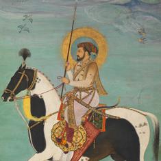


A map in the musty room of the National Archives of India shows Delhi in 1807, shortly after the arrival of the British in 1803. It highlights the hierarchy of settlements, from small to larger villages. The map marks out Shahajahanabad, Tughlaqabad, Mooralee and the Qutab Minar complex and is attributed to British surveyor FS White.
This illustration of Delhi in the 19th century is one of the first maps in Pilar Maria Guerrieri’s book, Maps Of Delhi.
“The smaller settlements are indicated only by name, and the delicate, miniature abstraction of villages, at times even trees, give this map an element of unique artistic expression,” writes Guerrieri about this map titled Sketch Of The Environs of Delhi.
.")
In her exquisitely produced book, Guerrieri arranges maps chronologically from as early as the beginning of the 19th century, to depict Delhi and the various influences that have caused its evolution into the city as we know it now.
In 2011, the architect chose India to do her PhD research in architectural design, architectural composition, criticism and theory. “Italy has a strong background in terms of using mapping as a tool to understand cities,” Guerrieri told Scroll.in. She was inspired by an Italian architect, Saverio Muratori, to study Delhi through its maps. Muratori had systematically surveyed Venice and Rome by comparing historical maps. Over the next three years, Guerrieri pored over old maps and books in dusty libraries, visited strangers’ houses when physically measuring areas and built up a collection of maps of which 61 have been published in the book.
The pre-independence maps included in the books are from the collection of maps drawn by British cartographers.
“At first, before the great 1857 rebellion, the colonialist sought to mingle with the local population and live inside Shahajahanabad. However, soon after the British assumed power over the subcontinent and had expelled the then Mughal emperor, they developed a practice of separating themselves,” writes Guerrieri. The maps in the book, up till 1911, demonstrate this phenomenon documented by the British. “They gradually relocated, first to the north with the military cantonments and residences in the Civil Lines area, then to the south in 1911, founding a new imperial city known as New Delhi.”
A significant event in the pre-independent India, the rebellion of 1857, has been demonstrated over a few maps. One particular pocket map, titled Siege of Delhi from that year, highlights the military operations planned by the British.
“The map... was certainly printed after Delhi was re-captured by the British, on the 22nd of September, 1857, since the grave of General Nicholson and ‘the spot where Gen Nicholson was shot’ are marked,” writes Guerrieri.
.")
“It remains ambiguous whether this map is a historical account of what transpired, since it marks the Enemy’s trench with Left Breach’ and Right Breach on either side of it, or if this map was to serve, effectively, as a pocket guide for future encounters with the rebelling forces,” she writes.
Following the rebellion, the British built a railway line and demolished parts of the Red Fort to prevent future mutinies. The maps and sketches of the city post-1857 reflect the New Delhi that the British planned to set up.
One such sketch, titled Lay Out Plan of New Delhi, gives details of the imperial New Delhi and illustrates land occupied by the government and its plans for future acquisitions.
.")
It marks out Connaught Place, the Viceroy house, the secretariats and the parliament.
A 1945 map in the Indian archives also shows the impact of World War II and where temporary buildings were erected for military purposes in Delhi. Apart from its importance as a military document, the map is insightful from an urban planning perspective. It is interesting to note that the map confirms that Lodi Colony had already been planned by this time as part of the Imperial Capital.
The plan, said Guerrieri, possibly became an integral model for future housing projects that would take place after Independence.
“Compared to the colonies of Karol Bagh or Jangpura, a visible improvement in the conception of design and layout becomes evident; the geometry of each block demonstrates a conscious relationship between residential buildings, per se, and the open spaces, private or semi-public, around it,” she writes.
.")
Post-independence
“Right after independence, there was an explosion of settlements in Delhi owing to the influx of refugees from all social strata into Delhi which gave birth to various inconsistently built colonies,” said Guerrieri. One of the maps created after independence, includes many of these refugee colonies – Patel Nagar, Lajpat Nagar and Nizamuddin.
.")
As we progress to the late 1990s, digital maps become the medium of choice. “The maps I like the most are the ones that have been beautifully drawn by hand,” said Guerrieri. “They are like works of art that one can almost imagine the cartographer forming an emotional and sentimental attachment to. Drawing of maps on paper or cloth is a lost art in this day and age of digital maps.”
The last map in the book shows the forthcoming Master Plan 2021 by the Municipal Corporation of Delhi. It depicts a vast increase in the urbanised area and the undeveloped areas in the map have been marked as “urbanisable”.
“Even though there is an indication to monuments, the map of the city has seemingly become detached from its conventional purpose; historical information is neglected and artistic and aesthetic values compromised in favour of a more methodical and arid scientific analysis,” writes Guerrieri.
.")