


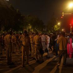


Over the past week, heavy rains have lashed the city of Chennai, bringing back painful memories of the December deluge in 2015 that left more than 300 people dead.
On October 30, the North East monsoon hit Tamil Nadu with a bang. Schools were shut for most of last week, and the state government issued a notice asking private companies to allow their employees to work from home.
On November 2, after six hours of incessant rainfall, several areas in southern and western Chennai were waterlogged. Fearing a repeat of the 2015 floods, more than 10,000 residents of low-lying areas took shelter in 114 relief centres in Chennai, Kancheepuram, Tiruvallur and Nagapattinam, the Tamil Nadu government said.
Despite the efforts of Chennai authorities to prepare for the monsoon by desilting rivers and building storm water drains, many low-lying residential areas find themselves under a few feet of water ever year.
The reason is simple. Most of these low-lying residential areas were once lakes.
A comparison of the 1909 map of Madras, the 1970 Survey of India map and a contemporary Google map shows how the city’s lakes have disappeared over the past century.
The Long Tank
 via Wikimedia Commons")
Today, there is no trace of the large water body marked on the map as the Long Tank. Over the past hundred years, densely populated neighbourhoods have been built on this lake, including Thyagaraya Nagar – known for its jewellery and sari shops. These areas now constitute central Chennai.
Vyasarpadi Tank

The erstwhile Vyasarpadi tank in northern Chennai now houses the Dr Ambedkar Government Arts College, as well as the homes of the poor in BV Colony and Saliman Colony. Traces of the tank can be seen in the Survey of India map of 1971. But in the present day map on Google Earth, the Vyasarpadi tank has entirely disappeared.
Velachery Lake and Adambakkam Lake

Parts of Velachery and surrounding areas were inundated by several feet of water during the floods of 2015. The neighbourhood continues to face water-logging and traffic jams every year, including this monsoon. A glance at the Survey of India map of 1970 shows that this is hardly surprising. Today, only a sliver of the lake still exists. The two Adambakkam lakes are not evident any longer.
Katteri Lake

In the 1970 map of Chennai, a lake called Katteri can be seen just below the winding Adyar River. Today, along this lake lies the Tamil Nadu Science and Technology Centre as well as the Tamil Nadu Electricity Board office of Taramani area.
Kodungaiyur Lake

The Kodungaiyur Lake of North Chennai no longer exists. In its place is Muthamizh Nagar, consisting of tightly-packed houses of the Tamil Nadu government housing board project.
Konnur Tank

The ground floors of many houses in SIDCO Nagar, which was developed on the Konnur tank, were submerged during the 2015 flood. While many parts of the city went under water in December, this area in Villivakkam of western Chennai faced intense water-logging through the month of November itself. The areas surrounding the lake frequently face flooding every year.