


As states prepare new Coastal Zone Management Plans that are long overdue, communities and environmentalists in many of these states are concerned. They say crucial details have been omitted in the draft plans, hindering effective public participation in the process.
On February 27, activists from the Coastal Resource Centre held a meeting in Chennai where they alleged the draft plan uploaded by the Tamil Nadu government on its website on February 19 inviting public comments was illegal and incomplete.
Under the Coastal Regulation Zone notification of 2011, each state is mandated to prepare a Coastal Zone Management Plan, which regulates activities in an area up to 500 metres from the High Tide Line. This line is the geospatial demarcation of the highest point reached by the rising tide along the coast. Regulating activities in this area is crucial for the protection of the coast and the livelihoods of coastal communities.
By failing to publish complete plans before calling for public consultation, the documents are in contempt of two orders of the National Green Tribunal, said activists in Tamil Nadu. “We are demanding that the plan be withdrawn immediately failing which citizens and fisherfolk will take to the streets,” said social activist Nityanand Jayaraman.
Tamil Nadu is not the only state where civic groups have found details missing from the draft plan. In Karnataka, researchers have found several discrepancies between the map and the actual contours of the coast. And in West Bengal, activists were unable to examine the plan closely as it was made available to them just one day before the public hearing.
Unreadable maps
The Coastal Zone Management Plan was originally supposed to be prepared for all states by 2013, within two years of the 2011 notification. But the deadline has been extended several times.
In the absence of these new plans, older plans prepared in 1995 have been given extensions at least five times. Even today, sanctions for all coastal development are given based on a plan that is more than two decades old.
Since last year, several coastal states have uploaded new draft maps in a language and format that is difficult for coastal communities to understand or respond to, said Kanchi Kohli, legal research director of the Namati Environmental Justice Program. “The public input process has been extremely limited and constrained,” she said.
In West Bengal, when a fishworkers’ union gained access to the state coastal plan for a limited period of time, they were unable to read and make sense of the markings. “We had expected the map to be in Bengali,” said Debasis Shyamal, vice-president of the Dakshinbanga Matsyajibi Forum. “How are we supposed to give our suggestions to the government if we cannot even read the plan?”
Fisherfolk in Tamil Nadu echoed the same concern. “Our livelihoods are directly impacted by this plan,” said R Srinivasan, president of the Kaatukuppam fisherfolk’s cooperative in North Chennai. “Already large tracts of land have been snatched from our hands by industries. To be able to secure what we have still, we need to be able to read the maps and make sure they are accurate.”
In Karnataka, researchers found that no one from the fishing community in Karwar district had attended a public hearing held there. Most fisherfolk were not aware the draft Coastal Zone Management Plan for Karnataka, divided into 32 maps, had been put up online on August 7, said Mahabaleshwar Hegde, a researcher at the Centre for Policy Research.
")
Omission of details
In their submissions to the Tamil Nadu and Karnataka governments, civic groups listed out the important details missing from the draft plans.
They said one crucial omission was the demarcation known as the Hazard Line, which maps areas vulnerable to waves, tides and sea level rise. The Coastal Regulation Zone notification restricts development even in areas where the Hazard Line lies beyond 500 metres from the High Tide Line. “Absence of this line makes the plans meaningless because there is no planning area that has been described,” said Nityanand Jayaraman.
In both states, activists claimed the draft plans did not mark the land use and livelihood spaces of the fishing community such as sections of the beach used for hauling the shore seine net, places where bait is caught, and net-mending and boat-parking areas. Coastal commons or fishing grounds of communities within rivers and the sea also have to be demarcated as per the 2011 notification, the activists pointed out.
Representatives of various fishing communities in Tamil Nadu complained that despite submitting maps for more than 35 villages prepared by the communities themselves, indicating community infrastructure and land use of coastal commons, the government had failed to reflect any of this.
In the maps of the Kanyakumari port site below, it is observed that an entire area of salt pans by the river that was protected by the 1996 Coastal Zone Management Plan (left) has not been recognised by the 2018 draft plan. In 1996, this part of the coast was marked as Coastal Regulation Zone I, an ecologically sensitive area where no construction is allowed. But in the draft plan, it is categorised as Coastal Regulation Zone III, where vacant plots can be constructed upon. Activists suspect these areas will be used to develop ancillary facilities for the proposed port.
 and the same on the 2018 draft Coastal Zone Management Plan.")
“We don’t want such important rules to be made in a hurry,” J Franco, a representative for the Kanyakumari fishing community, said at Tuesday’s meeting in Chennai. “The government has left out many acres of salt pans from the map of Kanyakumari, even though these are very important to us. The salt pans even helped reduce the effect of Cyclone Ockhi in some areas. But it appears as if they don’t exist in the maps. When something that exists is shown as if it doesn’t, we cannot help but feel suspicious of the government’s intentions.”
In Karnataka, researchers at the Centre for Policy Research found that several salt marshes, mangrove islands, rock cliffs and mud flats had not been marked in six of the maps they examined. The biggest omission was in Betkuli in Uttara Kannada district, where 600 acres of mangroves were left out of the protected zone. This is the area where the Tadadi port has been proposed.
However, coastal authorities were responsive to the suggestions provided, and visited the areas where Mahabaleshwar Hegde and his team pointed out irregularities. The officials assured them that they would incorporate the changes. But Hegde is still worried about the 26 other maps that have not been examined. “Even if they consider all our points, it may not be a solution,” Hegde said. “Will the authorities re-examine the rest of the maps or will they remain as they are? We don’t know yet.”
Lack of transparency
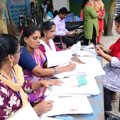
In some states, activists struggled to even get hold of the maps.
On December 2, the West Bengal government published a small notice in a newspaper in East Midnapur district, announcing the completion of a draft Coastal Zone Management Plan for the entire state, said Debasis Shyamal of the Dakshinbanga Matsyajibi Forum. The notice said a public hearing to discuss the plan would be held on December 5, and that details of the plan could be collected from the block development office in the district. However, since the office was closed over the weekend, civic groups could only collect the plan on December 4, a Monday, just a day before the meeting.
But when Shyamal and his colleagues visited the block office on December 4, they were not shown the plan even after waiting a few hours. It was only when they threatened to send a letter of complaint to the authorities that they were allowed to view the map.
The maps were in English, and therefore incomprehensible to the members of the fish workers’ union. Furthermore, they were not allowed to take copies of the plan, said Shyamal.
At the public hearing the next day, Shyamal submitted a memorandum to the State Coastal Zone Management Authority, stating that the way the public hearing process was being carried out was illegal. “It is not possible for the fishing community to fully understand the plans within a day and give their suggestions,” he said. “We asked them to make the maps available one month before the hearing as per the law.”
When Shyamal received no response from the coastal authority, the union filed an appeal with the Calcutta High Court, requesting its intervention. “But there is a lot of unrest in the Calcutta High Court at the moment, and our case has not yet been taken up,” he said.
")
Delayed plan
According to a detailed 2015 report by the Centre for Policy Research on coastal regulation, the State Coastal Zone Management Authorities faced difficulties in preparing the new plans, citing the process to be time-consuming and cost-intensive. Only a limited number of institutions could carry out these tasks, they said.
In 2014, to ensure uniformity in the plans, the National Coastal Zone Management Authority handed over the responsibility of generating the coastal maps to the National Centre for Sustainable Coastal Management, located within the Anna University campus in Chennai. The latest deadline was set by a National Green Tribunal order, by which the state coastal authorities have to submit plans by April 31 and the environment ministry has to approve them by July 31.
Researchers said that without the Coastal Zone Management Plans in place, authorities are using old demarcations for approval. In other instances, protection zones are being determined on a case by case basis, when project proponents submit tidal line demarcations with the help of institutions such as the National Institute of Oceanography. This has led to conflicts when projects are approved, said Kanchi Kohli.
“Coastal Zone Management Plans cannot be prepared without due public review and inputs,” she said. “Satellite maps have to be verified on the ground and this is best done with the partnership of the people living on the coast. In the present process that coastal zone management authorities are following, this is compromised, either due to lack of time or will.”