

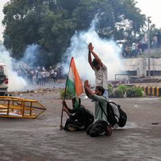


Soldiers at the Line of Actual Control in Ladakh are bracing for a hard winter. After the latest round of military and diplomatic talks, both sides have agreed not to pour fresh troops to the front. Going by reports, both sides agree on a roadmap to peace: disengage, de-escalate and eventually pull away troops from the area. But, at the moment, there are thousands of soldiers still massed along a cold frontier.
For months, Indian and Chinese troops have been battling for domination of key points on the disputed Line of Actual Control – the two countries cannot agree on where it actually lies. The flashpoints include the Galwan Valley and the banks of the Pangong Tso, both about 14,000 feet high, and Depsang, a region of gravelly plains that lie over 17,000 feet above sea level.
In October, winter will set in and temperatures will fall well below freezing point. Ladakh will be blanketed in snows that do not melt until May.
Despite talks, China is said to be setting up weapons platforms and air bases along the Line of Actual Control. India, for its part, has transported troops and supplies to the front. It has set the stage for a war of attrition on peaks where human presence has always been sparse. There could be a heavy price to pay.
The shadow of Siachen
By now, it is common sense that at such high altitudes the elements are a soldier’s worst enemy. Troops fighting at these heights must contend with blizzards, avalanches and hypothermia. Not to mention the thinning air and low oxygen levels. At Galwan this June, it is believed that some of the soldiers died of their wounds, unable to survive freezing temperatures overnight.
In ordinary times, 20,000-30,000 soldiers are stationed at Ladakh. Deployment is said to have doubled in the past few months. Through the winter, these troops must have enough heating, oxygen, nutrition and other equipment just to survive. According to reports, about 150,000 tonnes of supplies have already been transported to the region in preparation for winter.
The Siachen glacier, not far from the flashpoints in Eastern Ladakh, is a grim example of high altitude conflict. Since 1984, when the glacier became a new flashpoint in the Indo-Pakistan border conflict, over 1,000 Indian soldiers have been killed. Of these, at least 869 died because of climatic conditions at nearly 18,000 feet above sea level. India has reportedly spent about Rs 7,500 crore maintaining troops at the Siachen.
Apart from physiological constraints, writes researcher Aidan Milliff, the rules of warfare are changed at such high altitudes. Low pressure at high altitudes can cause corneal distortion, leading to shortsightedness, impairing depth perception and low light vision, which means weapons would have to be re-sighted accordingly. Troops cannot be rushed to the front without being acclimatised first. Resupplying soldiers, should it be necessary, is costly and physically difficult in winter. Even rifle rounds and artillery shells fly differently, as soldiers found in Kargil in 1999.

Fragile ecologies
Beyond the cost in lives and resources is another silent loss. Ecologically fragile environments form the theatre for the conflict along the Line of Actual Control, including glaciers that feed into the Indus, Brahmaputra and Tarim basins and are crucial to supplying water for millions.
These lives depend on tenuous pacts between countries on sharing water and data that are constantly jeopardised by border conflicts. After the 2019 Pulwama blast triggered tensions with Pakistan, India threatened to walk out of the Indus Waters Treaty, which had endured through decades of fighting. After the Doklam clashes in 2017, China stopped sharing monsoon data, critical to flood management in the Brahmaputra basin. The deadly June clashes took place near the confluence of the Galwan river and the Shyok river, a tributary of the Indus and a reliable source of water for local farmers.
Then there are dystopic reports of waste collecting at the Siachen glacier – an average of 236 tonnes a year, much of it non-biodegradable and metallic. There are habitats of endangered species and rare flora that could be wiped out by conflict. As climate change melts glaciers and threatens the water security of millions, these landscapes acquire even more significance. Ecologists argue that the environmental importance of the Himalayan region must outweigh geopolitical calculations.
Where borders don’t work
The Indo-China dispute may have taken the two armies into regions where borders do not work, suggest authors Ruth Gamble and Alexander E Davis. Till the early 20th century, this was the region of colliding empires, as Russia, Britain and China fought for influence and control of trade routes.
British claims on the region were made through the Dogra princely state of Jammu and Kashmir – which had absorbed the kingdom of Ladakh – established in 1846. The Dogras had scant presence in the north eastern reaches of their state and a foggy idea of where the boundary lay. British cartographic expeditions through the late 19th century did try to establish a boundary but these maps were contested and imperial powers had little physical presence in such areas. The ambiguity persisted after India became independent.
In the early maps drawn after Independence, the northern frontier is marked as “undefined”. The prescriptive line showing the contours of the former princely state of Jammu and Kashmir seemed to refer vaguely to “traditional boundaries”. It was only in 1954, when Prime Minister Jawaharlal Nehru ordered the drawing of a “firm and definite boundary” that cartographic borders solidified.
The colonial project of cartography had attempted to impose linear borders, establishing well-defined claims of sovereignty, on a region of frontiers, wide tracts that served as buffer regions between states. Nation states such as India and China inherited the colonial idea of a border. Then they attempted to “territorialise” these high-altitude regions, Gamble and Davis argue. Men, guns, roads, bridges and bases were to impose the logic of national borders.
As border disputes broke out, lines of control between armies were also territorialised. Even then, regions like the Siachen glacier were undefined for decades. When the Line of Control between India and Pakistan was drawn in 1948, it was delineated up to the grid reference NJ9842, just south of Siachen. At this point it was “thence North to the glaciers”; India and Pakistan had differing perceptions on what that term meant. The glacier was left alone until expeditions from the Pakistan side prompted India to occupy the heights in 1984, kickstarting a slow and grinding conflict.
In some places, the claims of modern states cut off traditional flows – for instance, the Depsang plains had once been on the caravan route into Central Asia but that traffic stopped in the 1950s with the rise in Indo-Chinese border tensions. The high peaks that are now contested were largely uninhabited apart from nomadic communities who have little time for national borders. Until the recent clashes, local residents say, herders from both countries across border regions in search of pasture without being harassed. These communities now worry for their livelihood.
Alternative frontiers
As talks grow strained, there is concern on the Indian side that a protracted stand-off means China will project its territorial gains as a fait accompli and force India to accept the new status quo. Much of the discussion has centred on how India must push for status quo ante the deadly June clashes or the recognition of its claimed Line of Actual Control.
But as the two countries try to stare each other down, some suggest that lines on a map are not the only way to imagine these border regions. Ecologists argue that high-altitude areas such as Galwan should be kept free of human interference and the fragile mountain ranges be turned into a vast nature reserve spanning across national borders. Leaders in Ladakh have spoken of a solution that puts the interest of local communities first. On a visit to Siachen in 2005, then Prime Minister Manmohan Singh even proposed demilitarising the glacier for a “peace park”.
For now, these seem like distant prospects, with both countries making territorial claims by expanding infrastructure. While India expands its network of highways, China sees the region as crucial to that grand fantasy of hegemony: the belt and road project.
Which means that both countries are engaged in a punishing stand-off in a region where borders have been hard to impose. Neither country needed to fight this battle.