


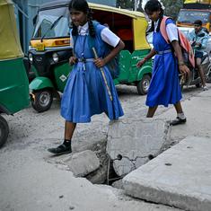


Ram Avdesh Singh, the sarpanch of the Nakta Diyara panchayat near Patna, was a worried man as he co-ordinated a meal of khichdi and chokha for the residents of his village. The settlement is now under chest-deep water and all its residents are housed in a temporary camp on the banks of a swollen Ganga.
“We are used to floods. Even our kids aren’t scared of the water,” said Singh. “But this was massive. I’ve never seen a flood this big since 1975. And that too suddenly – it didn’t even rain.”
Man versus nature
This unusual flooding in Bihar has been caused by a spate in the Gangetic river system. The Ganga as well as its tributaries such as the Sone, Burhi Gandak, Ghaghra and the Kosi are flowing well above normal levels. In Patna, the Ganga set a new record on Sunday, with water rising to 50.52 meters at Gandhi Ghat on the city's outskirts.
Twelve districts are now flooded severely, with more than 60 lakh Biharis affected. A total of 127 people have died since the floods began. Even for a state used to floods, this is the worst such tragedy in a generation.

Given the scale of the inundation, it is odd to note that between June 1 and August 17, India received only an average quota of rainfall. Bihar, in fact, got 14% less precipitation than is normal during this period. This time, at least, natural events cannot be blamed for the flooding. Instead, India’s poor water management policy seems to be at fault. The country’s dependence on large dams, built without environmental checks and balances has upset the Gangetic water system enough to have caused this widespread, unusual flooding.
Dam nation
The river Sone flows through Madhya Pradesh before it enters Bihar. There, around 50 km south of Rewa town, the Bansagara Dam has been constructed on the Sone river. As is becoming increasingly clear now, the dam, which was opened in 2006, had a major role to play in causing these floods.
Unlike Bihar, central India received excessive rainfall during the current monsoon. Eastern Madhya Pradesh, in which the Bansagar Dam is located, received 30% more rain that is normal.
As a result of this rain, the dam’s reservoir were close to its maximum for the first half of August. With more rains expected at the end of the month, the dam should have released this water slowly in order to make room for more.
The authorities did release the water, but at one go. The Times of India reported that when it was running at 95% capacity, the dam opened 16 of its 18 gates on August 19. This excess water flooded the Sone, which in turn emptied itself out into the Ganga, causing the massive flooding from which Bihar is now suffering
Siltation problem
While the Bansagar dam the short-term cause, the real reason for these floods is a long term one: silting of the Ganges river and its tributaries. Bihar Chief Minister Nitish Kumar met Prime Minister Modi on August 23 and requested that he put in place a national silt management policy. The collection of silt had decreased the capacity of the Ganga, increasing chances of flooding.
Kumar was also clear on what had caused this increase in silt: the Farakka Barrage, situated on the West Bengal-Bangladesh border.
As the Ganga enters the Bengal region, it continues into Bangladesh as the river Padma. However, a major distributary of the Ganga splits off and continues into West Bengal and is called the Bhagirathi in its upper reaches and the Hooghly as it reaches the Bay of Bengal. Kolkata city lies on the mouth of the Hooghly and the city’s port is a major centre of trade.
Farakka Barrage construction
By the 1960s, siltation was threatening the Kolkata port, the process in itself driven by another dam, the Damodar dam, which had made the water reaching Kolkata sluggish. As a solution, the Farakka Barrage was commissioned in 1975. The Barrage would divert the waters of the Ganga away from the Padma – its natural channel – and into the Hooghly in order to flush away sediment and resuscitate the Kolkata port.
However, no environmental assessment was done for the project and its effect on the massive Ganges basin was not studied. The few voices that spoke against the dam were ignored. Notable among them was Kapil Bhattacharya, the engineer-in-chief of West Bengal, who had predicted the siltation upstream the dam would cause – and the floods that would take place as a result.
After it was built, not only did the barrage cause massive siltation across the Ganges system, bank erosion in West Bengal and decrease of water in Bangladesh’s Padma, its main aim – to desilt the Kolkata Port – was never achieved. A report by the South Asia Network on Dams, Rivers and People points out that the Kolkata Port Trust needs to manually remove silt from the port every year to keep it running. So expensive is this desilation that in December 2015, the Chief Economic Advisor to the Union government Arvind Subramanian advised the West Bengal government to shut down the port. It would be more economically efficient to utilise the port’s vast land area for other activities, argued Subramanian.
Even as India struggles with the damage done by the poorly conceptualised Farakka Barrage, exports point out that it should also keep this lesson in mind when its policy makers think up water management schemes such as interlinking rivers across India.