


Areas previously with human habitation, turning into bare, flattened mud grounds, scattered with rock boulders, are now a familiar sight for the people of Kerala. The 2018 deluge that killed over 450 people shifted the state to a disaster-vulnerable state, with a consecutive flood in 2019 and devastating landslides in the years following.
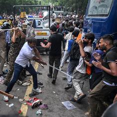
The state woke up to similar sights on July 30 when a catastrophic landslide occurred in the serene, northern district of Wayanad. According to the press statement early on August 2,from the Chief Minister’s Office,199 people have been reported as dead so far. Another 86 people are undergoing treatment.
The state quickly resorted to rescue operations and risk management, even as experts and environmentalists criticised the government for not developing a strategy for risk mitigation.
The origin of the calamity is reported to be the Iruvazhinjhi river which flows down to three villages named Mundakkai, Chooralmala, and Attamala in Vythiri taluk and merges with the Chaliyar river. Twenty-six dead bodies, along with several unidentified body parts, were found in the Chaliyar river at Pothukallu in Malappuram, a nearby district. The landslide also completely buried a government vocational higher secondary school.
Kerala Chief Minister Pinarayi Vijayan called it one of the worst disasters the state ever witnessed. The state has previously witnessed devastating landslides in Pettimudi in the Idukki district in 2020, which killed 66 people, in Kavalappara in Malappuram in 2019, which killed 46 people, and Puthumala in Wayanad, in which 11 people lost their lives. Relentless, heavy monsoon triggered these landslides.
Sridhar Radhakrishnan, an environmentalist, considers the landslide as the outcome of the state overlooking risk mitigation. “The approach should be about setting up risk assessments and mitigative measures, creating a resilient strategy, but instead, it is about disaster management, and the state has mastered it,” he told Mongabay India.
Sridhar pointed out that a landslide happened in the same region in 1984, and because of the landslide in Puthumala in 2019, the region has been identified as a landslide-prone area, which means that the authorities have to be more vigilant about these regions when there are incessant heavy rains. He suggested shifting people from these regions to safer areas gradually but permanently.
“The rehabilitation didn’t happen even in the high-priority areas. When something like this happens, you should have an early warning system,” Sridhar said. “There should be a warning system for landslides which is same as in the case of heavy rains. It happened not because of a human error but because of human negligence. If warnings had been taken seriously, there would have been enough time to move people out. Landslides can’t be avoided, but causalities can.”
Mass graves being dug on a war-time basis in a public graveyard in #Wayanad to bury unidentified body parts of landslide victims' fished out from the Chaliyar river and adjoining sites. The remains are in extremely bad condition, said officials. pic.twitter.com/0lnv7XmpQH
— Vishnu Varma (@VishKVarma) August 2, 2024
Importance of alerts
The Hume Centre for Ecology and Wildlife Biology has been collecting, analysing, and sharing data on rainfall in Wayanad district, since 2018. “We have a daily updating system,” CK Vishnudas, Director of Hume, told Mongabay India. “The updates are put on a group in which all the stakeholders, like the District Collector and Disaster Management Authority people, are there. We have a clear daily analysis, providing separate data on highly saturated regions, averages about panchayat, and district-wise details. Also, we have a grid that analyses the rainfall every 25 kilometres. Even on July 31, two regions crossed 4000 millimetres of rainfall; in two other places the rainfall was 3600 mm; this is heavy. Normally, rainfall would come to 3000 mm in the monsoon. But this year, it has been consistently heavy rains, and by July 20, soil became saturated in all regions. Soil saturation water-bearing capacity means streams would originate, water flows out of them, and heavy water inflow in all rivers.”
The district had witnessed landslides in the same region in 2020, and the authorities shifted people because of the alerts provided by Hume, he claimed. “This year, our warning has specific details about soil saturation and the vulnerable regions, naming the villages that have been cut off. We had given an update about the intensive rainfall and a warning that this could be the expected rainfall in the region overnight, which could trigger a landslide,” he added. But there has yet to be a proactive step from the authorities. “This is something we could have avoided, I stand by that,” he asserted.
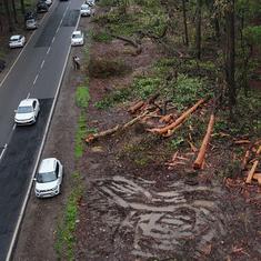
Experts say that there should be a focus on mitigating risks and action based on precise warnings on soil saturation and vulnerable areas, that are available, could help mitigating the impact of landslides in the district. Image by special arrangement.
“Water has memory, it remembers its course, even centuries after it was diverted. It’s dangerous to attempt to trick nature by occupying the path of a river.”
— Dolly Kikon (@DollyKikon) August 2, 2024
‘The river reclaimed its course’: Geologist explains Wayanad landslide https://t.co/v7DJg7MLtv #
Meanwhile, in a Rajya Sabha speech on July 31, Union Home Minister Amit Shah said that the Centre gave early warnings to the Kerala government on July 23, seven days before the incident. On July 26, he said, a warning was given there was a chance of heavy rainfall of more than 20 centimetres and there were chances of landslides. He questioned why there was inaction by the state government despite the warnings.
However, Kerala Chief Minister Pinarayi Vijayan, refuted the claim, saying that the Union Home Minister has presented information in the Parliament that is inconsistent with the facts. The chief minister added that the India Meteorological Department’s warning was that rainfall would be between 115 and 204 mm. However, the actual rainfall – 572 mm in 48 hours – was much higher. The area received 200 mm of rain in the first 24 hours and 372 mm in the next 24 hours.
“The area had never been on red alert before the disaster,” the chief minsiter said at a press conference. “However, after the incident, a red alert was issued at six o’clock in the morning [of July 30] after the landslides occurred. On July 29 at 2 pm, the Geological Survey of India issued a green alert for July 30 and 31, indicating a possibility of minor landslides or rock bursts. However, by that time, heavy rain had already occurred, and the landslide had taken place.”
From July 23 to 29, the Central Water Commission, responsible for issuing flood warnings, did not issue any warnings for either Iruvazhinji Puzha or Chaliyar, he added.
Warming Arabian sea
S Abhilash, Director of the Advanced Centre for Atmospheric Radar Research at the Cochin University of Science and Technology attributed the excessive rainfall to the cloudbursts from high water accumulation over the southeastern part of the Arabian Sea. The Arabian sea lies to the west of Kerala. Earlier research by Abhilash and others found that rainfall over the west coast of India is becoming more convective.
“Cloudbursts occurring under favourable ocean-atmospheric conditions may leave a vast area of the state vulnerable to flash floods and landslides anytime during the monsoon season,” he said. “The paper [published in 2022] was based on the Kavalappara and Puthumala landslide. Post that, such disasters kept occurring, landslides happened in Pettimudi [Idukki district] in 2020, in Koottickal [Kottayam district] in 2021, and a major cloudburst in Kalamassery in Kochi [the first-ever cloudburst in the state in May 2024]. As an indication of cloudburst, we cited the increasing depth of clouds forming in the southeastern Arabian Sea, causing increasing rainfall.”
According to him, the warming of the Arabian Sea and the increasing depth of cloud is a clear signal of climate change. “Earlier, the clouds in the southeastern part of the Arabian Sea were mostly formed in the northern region, which caused frequent landslides in the Konkan region,” said Abhilash. “A mesoscale mini cloudburst has the potential to trigger a landslide or cause a flood if the rainfall is ten centimetres to 15 centimetres in one hour, considering the vulnerability of the Western Ghats. Mini cloudbursts in this region will have the same impact that the major cloudbursts have in the Himalayan region.”
He also blamed the authorities for not issuing a warning, sensing the pattern of the rains. “This is not because of the lack of data; we should be able to sense from the rain pattern,” he said. “The alert system is not reaching the last mile people.”
A source in the government, who asked for anonymity, rejected this claim, saying that appropriate action was taken and the deaths occurred six kilometres away from the area where the landslide originated.
Landslide impacts
Sajin Kumar KS, a geologist and Assistant Professor at the University of Kerala, also said that the recent landslide occurred six kilometres inside a dense forest. “Factors ignored were those that could be ignored,” he said. “There was no anthropogenic influence. There are many landslide susceptibility maps prepared by different methods, and if you place the latitude and longitude of the [recent] landslide, it falls exactly under the high landslide zone of that area.”
He noted that while the landslide prediction was accurate, the impact of the landslide that flowed beyond the point of origin, was in regions, which are not usually landslide prone, such as Chooralmala, because of the way it flowed.
In 2018, Sajin Kumar coordinated a five-day study about landslides in Idukki during the floods that year and concluded that human activity and presence was the reason for the landslides in Idukki.
Talking about the recent disaster, Sajin Kumar said, “Two things went wrong. One is people living on the banks of rivers on the plains where water can flow during the heavy monsoon seasons. Two, we don’t have a map predicting the flow path of the landslide, the direction it flows, we lack that modeling. This is an area of active interest worldwide. Almost all developing countries are about to develop such a map, but we are in the infant stage. All the devastating landslides occurred in the non-susceptible areas, especially Pettimudi, Puthumala, and the latest one – the origin of the landslide was in a susceptible area, the casualty occurred in a landslide-free zone.”
The non-implementation of the Western Ghats Ecology Expert Panel report, led by prominent ecologist Madhav Gadgil, which warned against anti-environmental activities in eco-sensitive areas in Wayanad, has also been brought up by experts, after the recent landslide. Environmentalist Sridhar Radhakrishnan blamed this non-implementation on successive state governments.
Sajin Kumar, however, has a different view. “…The [recent] landslide occurred in deep forests where human beings didn’t even enter. Not only Gadgil’s report but any Geological Survey of India map shows it as a landslide-prone area. Any map will say that. But that is not the point. We failed to identify the areas that the landslide will flow down to. The government should shift people and take precautionary measures based on quantifying the rainfall threshold, and how much is required to trigger a landslide. The government authorities acted based on this rainfall prediction, on July 30, rehabilitating people from six residential areas. The government issued an orange alert for the region though it later turned into a red alert,.”
Technically the government does not have the authority to move people living in the safer zones, he added, referring to the non-landslide prone zones, where, in fact, the impact of the recent landslide was seen as the landslide flowed. The origin of the landslide is predictable but its pathway, which are the areas through which it will move, is not predictable and hence it is not always possible to send alerts for those areas, he explained.
“An insert soil moisture testing instrument can be used to check soil water content and threshold. But the most important is landslide runout zone mapping,” he suggested. Landslide runout analysis is used to simulate the motion of past landslides to predict the motion of potential future landslides. This is often required in the context of a landslide hazard or risk assessment.
Abhilash said that the authorities failed in risk mitigation which experts have been advocating for since the Cyclone Ockhi in 2017. He hoped calamities of lesser magnitude in the future will not be trivialised solely because the state witnessed something of this magnitude.
This article first appeared on Mongabay India.